 Filter: Categories of Wisconsin Historical Images
Filter: Subject of Trails
Filter: Subject of water
Filter: Categories of Wisconsin Historical Images
Filter: Subject of Trails
Filter: Subject of water
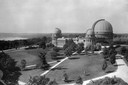
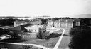
| Date: | 1935 |
|---|---|
| Description: | Elevated exterior view of Yerkes Observatory. Geneva Lake is in the background, left. Roads and sidewalks cross the sweeping, well tended lawns. The desi... |

| Date: | 1936 |
|---|---|
| Description: | This map is red and black ink on tracing cloth and is oriented with north to the upper left. This hand-drawn map shows a central portion of the military ro... |
| Date: | 05 27 1849 |
|---|---|
| Description: | The wagon train crossing Laramie Creek in Wyoming. |

| Date: | 06 24 1849 |
|---|---|
| Description: | Original wash drawing of Fort Laramie, Wyoming (actually Fort John; see note below). Sketched by Wilkins on his 151-day journey from Missouri to California... |
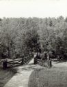
| Date: | |
|---|---|
| Description: | Two people on a rustic bridge over Bad River at Copper Falls State Park. |
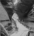
| Date: | |
|---|---|
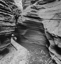
| Description: | Looking out of the entrance to Witches' Gulch showing wooden walkway. |
| Date: | |
|---|---|
| Description: | Fat Man's Misery, the narrow defile in Cold Water Canyon. |
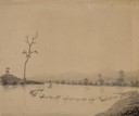
| Date: | |
|---|---|
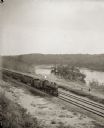
| Description: | Elevated view of a train running parallel to the river, past the Ink Stand. Several people are standing along the tracks and waving. |
| Date: | 06 27 1931 |
|---|---|
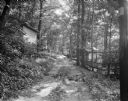
| Description: | Path, "main street," through the woods at the University of Wisconsin Tent Colony. Also known as Camp Gallistella on the south shore of Lake Mendota, west ... |
| Date: | 1926 |
|---|---|
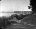
| Description: | Lake Mendota, including Fraternity Row and east side shoreline, taken from the lake path on University Bay Drive. |
| Date: | 1926 |
|---|---|
| Description: | View of Adams, Tripp and Van Hise Halls. All are residence halls on the University of Wisconsin campus with Picnic Point and Lake Mendota in the backgroun... |

| Date: | 1945 |
|---|---|
| Description: | View of the lower campus of the University of Wisconsin-Madison includes Bascom Hill, Wisconsin Historical Society, Memorial Union and the Armory (Red Gym ... |

| Date: | 1945 |
|---|---|
| Description: | Aerial view of Bascom Hill, Bascom Hall, Wisconsin Historical Society on the University of Wisconsin Madison campus with Lake Mendota on the right. |
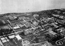
| Date: | 1923 |
|---|---|
| Description: | Aerial view of the University of Wisconsin campus shows from west to east the Agricultural Hall, Observatory Hall and the Wisconsin Historical Society with... |

| Date: | 1926 |
|---|---|
| Description: | Originally titled 'Recent Aeroplane View of University Campus', the view of the Wisconsin Historical Society, the Red Gym, Science Hall and Bascom Hall wit... |

| Date: | 1923 |
|---|---|
| Description: | Aerial view of the Wisconsin Historical Society, Science Hall, and Bascom Hall on Bascom Hill on the University of Wisconsin-Madison campus. Lake Mendota i... |
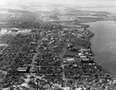
| Date: | 1946 |
|---|---|
| Description: | Aerial view of the University of Wisconsin campus with Lake Mendota on the right. |

| Date: | 1908 |
|---|---|
| Description: | Drawing of the general design for future construction development at the University of Wisconsin with the Barn, Sheep Barn, Horse Barn, House, Power House,... |

| Date: | 1908 |
|---|---|
| Description: | General design for future construction development of the University of Madison campus with the general view of the campus by the Architectural commission. |

| Date: | 1910 |
|---|---|
| Description: | Elevated view of Bascom Hill on the University of Wisconsin-Madison campus from the south between the Chemistry Building and Lake Mendota. |
If you didn't find the material you searched for, our Library Reference Staff can help.
Call our reference desk at 608-264-6535 or email us at: