 Filter: Categories of Wisconsin Historical Images
Filter: Subject of Trails
Filter: Subject of
Filter: Categories of Wisconsin Historical Images
Filter: Subject of Trails
Filter: Subject of
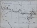
| Date: | 1949 |
|---|---|
| Description: | This map traces the route taken Chief Black Hawk from Vernon County, Wisconsin east to Waukesha County and south to Rock County, Wisconsin in 1832. Towns, ... |

| Date: | 1794 |
|---|---|
| Description: | Extremely detailed map of the south-eastern states, south from Virginia and east of the Mississippi River. It shows roads and paths, cities, towns, forts, ... |
If you didn't find the material you searched for, our Library Reference Staff can help.
Call our reference desk at 608-264-6535 or email us at: