 Filter: Categories of Wisconsin Historical Images
Filter: Subject of Trails
Filter: Community of Madison
Filter: Subject of persons
Filter: Categories of Wisconsin Historical Images
Filter: Subject of Trails
Filter: Community of Madison
Filter: Subject of persons
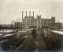
| Date: | 1924 |
|---|---|
| Description: | Two women standing on path in front of the Garver Feed Mill, which was originally a sugar beet processing factory. |
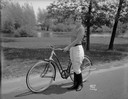
| Date: | 05 23 1933 |
|---|---|
| Description: | Janette Serrec, lecturer and writer on the "Fine Art of Successful Living," standing beside a Hawthorne bicycle from Ward's. She is wearing jodhpurs and bo... |
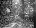
| Date: | 06 27 1931 |
|---|---|
| Description: | Path, "main street," through the woods at the University of Wisconsin Tent Colony. Also known as Camp Gallistella on the south shore of Lake Mendota, west ... |
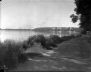
| Date: | 1926 |
|---|---|
| Description: | Lake Mendota, including Fraternity Row and east side shoreline, taken from the lake path on University Bay Drive. |
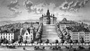
| Date: | 1885 |
|---|---|
| Description: | A view of what is now known as Bascom Hill including Main Hall (Bascom Hall), North Hall, Music Hall, Science Hall, South Hall, Washburn Observatory and Wo... |
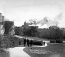
| Date: | 10 10 1916 |
|---|---|
| Description: | People walking along the Linden Drive path watch as Bascom Hall (formerly Main Hall) dome burns on the University of Wisconsin-Madison campus. Fire destroy... |
| Date: | 1909 |
|---|---|
| Description: | A billboard displays events at the foot of Bascom Hill from the bottom east side on the University of Wisconsin-Madison campus. Bascom Hall with dome (form... |
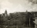
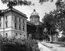
| Date: | 1900 |
|---|---|
| Description: | The view of Bascom Hill and upper campus of the University of Wisconsin Madison seen from the roof of the Wisconsin Historical Society. |
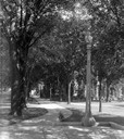
| Date: | 1926 |
|---|---|
| Description: | View from the top of Bascom Hill on the University of Wisconsin-Madison campus of the tree-lined path and lampposts. South Hall is on the right. |

| Date: | 1945 |
|---|---|
| Description: | View of the lower campus of the University of Wisconsin-Madison includes Bascom Hill, Wisconsin Historical Society, Memorial Union and the Armory (Red Gym ... |

| Date: | 1926 |
|---|---|
| Description: | Originally titled 'Recent Aeroplane View of University Campus', the view of the Wisconsin Historical Society, the Red Gym, Science Hall and Bascom Hall wit... |

| Date: | 1923 |
|---|---|
| Description: | Aerial view of the Wisconsin Historical Society, Science Hall, and Bascom Hall on Bascom Hill on the University of Wisconsin-Madison campus. Lake Mendota i... |
| Date: | 1915 |
|---|---|
| Description: | South view of Bascom Hall (formerly Main Hall) with dome on the University of Wisconsin-Madison campus. A flag is flying from the dome. |
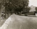
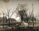
| Date: | 1922 |
|---|---|
| Description: | View of tree-lined Linden Drive includes parked motorcycles and automobiles on the University of Wisconsin campus. |
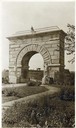
| Date: | 1912 |
|---|---|
| Description: | Camp Randall Memorial Arch and Civil War cannons honor the Wisconsin Civil War soldiers on the University of Wisconsin-Madison campus. The memorial was nam... |
| Date: | 1936 |
|---|---|
| Description: | Camp Randall Memorial Arch with a gated path. |
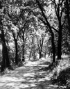
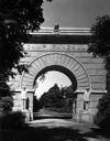
| Date: | 1930 |
|---|---|
| Description: | View of the Lakeshore Path in Bascom Woods by Lake Mendota, later dedicated the Howard M. Temin Lake Shore Path on the University of Wisconsin-Madison camp... |

| Date: | 1956 |
|---|---|
| Description: | Aerial view of lower University of Wisconsin-Madison campus with demolition of buildings on both sides of the Armory-Gymnasium to make space for future pla... |

| Date: | 1907 |
|---|---|
| Description: | The Yahara River Parkway, with the old Lapham School at 1436 East Dayton Street at North Thornton visible on the righthand side. |

| Date: | 1906 |
|---|---|
| Description: | View from shoreline looking over a pathway towards the Steensland Bridge and Yahara River Parkway at East Washington Avenue. |
If you didn't find the material you searched for, our Library Reference Staff can help.
Call our reference desk at 608-264-6535 or email us at: