 Filter: Categories of Wisconsin Historical Images
Filter: Subject of Traffic signs and signals
Filter: Year of 1900-1999
Filter: Categories of Wisconsin Historical Images
Filter: Subject of Traffic signs and signals
Filter: Year of 1900-1999
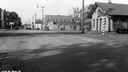
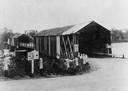
| Date: | 10 10 1939 |
|---|---|
| Description: | Railroad crossing, also showing the main street and the train depot. |
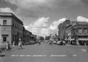
| Date: | 1944 |
|---|---|
| Description: | View of intersection with pedestrians crossing the street in the town central business district. Businesses include three drugstores, a hotel, and a clothi... |
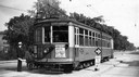
| Date: | 06 1947 |
|---|---|
| Description: | A family boarding a route #40 streetcar. A sign on the front of the car advertises midget auto racing at the State Fair grounds; the second urges people to... |
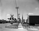
| Date: | 06 16 1963 |
|---|---|
| Description: | View down street towards the Menasha railroad crossing and a Roman Catholic Church. |
| Date: | 1935 |
|---|---|
| Description: | View of covered bridge above the Wisconsin River, 1 mile from Boscobel. |

| Date: | 1950 |
|---|---|
| Description: | Caption reads: "Looking West on Main Ave." View down center of commercial area, with automobiles moving down the street, and parked along the curbs. A U.S.... |
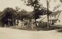
| Date: | 1929 |
|---|---|
| Description: | Residential block of North Sherman Avenue between McPherson and Farragut Street, across from Sherman School. |
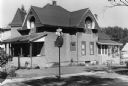
| Date: | 03 19 1972 |
|---|---|
| Description: | Exterior view of a house at 702 West Olin Avenue. It was built in either 1904 or 1890. Currently many of the architectural details have been removed, but i... |

| Date: | 1955 |
|---|---|
| Description: | Exterior view of a post office. Caption reads: "Post Office — Walworth, Wisconsin". |
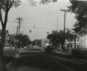
| Date: | 1955 |
|---|---|
| Description: | The intersection of Johnson and Broom Streets. |

| Date: | 1951 |
|---|---|
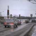
| Description: | Sunday morning traffic on the corner of Washington and South 8th Streets in Manitowoc. |
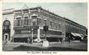
| Date: | 1925 |
|---|---|
| Description: | Exterior view from intersection towards The Big Store on the corner, with two men standing outside the entrance. A large traffic signal is in the center of... |

| Date: | 1955 |
|---|---|
| Description: | Midvale Avenue and Odana Boulevard. |
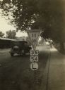
| Date: | 1925 |
|---|---|
| Description: | Wisconsin State Highway sign along STH 11 near Galesville, one of a whole new vocabulary of signage created for automobile traffic. The inverted triangle w... |
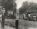
| Date: | 1917 |
|---|---|
| Description: | These two signs located along the route of Wisconsin State Trunk Highway 15 and 16 indicate the presence of a culvert. Beginning in 1917 Wisconsin pioneer... |
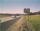
| Date: | 10 1961 |
|---|---|
| Description: | An Interstate I-90/94 sign near Portage taken by the Division of Tourism. |
| Date: | 1981 |
|---|---|
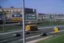
| Description: | Fond du Lac Avenue (State Highway 145) exit from Interstate I-43 in Milwaukee. As originally conceived, the interstate system in Wisconsin was to consist ... |
| Date: | 02 02 1967 |
|---|---|
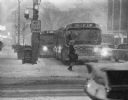
| Description: | Winter scene of a snowstorm that hit Milwaukee just at rush hour creating a traffic headache for homebound commuters (seen here at Wisconsin and Milwaukee ... |
| Date: | 02 1977 |
|---|---|
| Description: | Automobile exhaust on a cold February morning in Milwaukee. |
| Date: | 1924 |
|---|---|
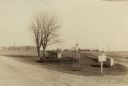
| Description: | Fort Winnebago monument two miles east of Portage on Highway 33, erected by the Wau-bun Chapter of the Daughters of the American Revolution in 1924. The mo... |
If you didn't find the material you searched for, our Library Reference Staff can help.
Call our reference desk at 608-264-6535 or email us at: