 Filter: Categories of Wisconsin Historical Images
Filter: Subject of Tourism
Filter: Year of 1900-1999
Filter: Year of 1990-1999
Filter: Categories of Wisconsin Historical Images
Filter: Subject of Tourism
Filter: Year of 1900-1999
Filter: Year of 1990-1999
| Date: | 1998 |
|---|---|
| Description: | Not only does the cranberry industry produce cranberries, but it is also a source of tourists during the colorful harvest season. |

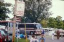
| Date: | 06 1990 |
|---|---|
| Description: | Actor Mark Harmon (center), who portrayed John Dillinger in the made-for-TV movie of the same name, at the Chalet on the Lake in Mequon. In the film this ... |

| Date: | 1990 |
|---|---|
| Description: | Director Rupert Wainwright holding a "Dillinger Shot-in-Wisconsin" t-shirt. With him is Dick Matty, secretary of the Wisconsin Department of Tourism, of w... |
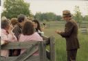
| Date: | 1990 |
|---|---|
| Description: | Costumed for the lead role in the made-for-TV movie "Dillinger," actor Mark Harmon signs autographs for some tourists who were visiting Old World Wisconsin... |
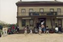
| Date: | 1990 |
|---|---|
| Description: | Tourists visit the historic Seven-Mile Inn at Old World Wisconsin transformed for its role as the Daleyville Bank in the ABC made-for-TV movie "Dillinger". |

| Date: | 1990 |
|---|---|
| Description: | A tourist map of Lafayette County, Wisconsin, that shows the locations of motels, camping, municipal parks, cheese factory tours, waysides, and golf course... |

| Date: | 1990 |
|---|---|
| Description: | This tourism brochure of Ashland County, Wisconsin, from the Ashland Area Chamber of Commerce includes a map of the county showing tourist destinations and... |

| Date: | 1995 |
|---|---|
| Description: | This map of La Crosse is a bird’s-eye-view map with relief shown pictorially. The cover lists many points of interests and activities in La Crosse. The cov... |

| Date: | 1990 |
|---|---|
| Description: | This map shows the Minnesota Point, Wisconsin Point, Hog Island, Baker's Island, Connors Point, Blatnik Bridge, Superior Bay, Allouez Bay, the Nemadji Rive... |

| Date: | 1990 |
|---|---|
| Description: | This map shows various types of trails, boat landings, canoe areas, public beaches, picnic areas, campgrounds, golf courses, public tennis courts, and othe... |

| Date: | 1994 |
|---|---|
| Description: | This map shows historical sites, picnic grounds, public boat landings, canoe and motor boat trips, and resort locations. The left margin of the map include... |

| Date: | 1991 |
|---|---|
| Description: | This map shows public access, fish crib locations, resorts, and other local businesses as well as advertisements for local attractions and a resort index. ... |
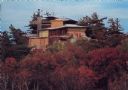
| Date: | 07 25 1995 |
|---|---|
| Description: | Text on the reverse reads: "The House on the Rock. Spring Green, Wisconsin 53588. The House on the Rock comes alive with spectacular autumn colors. This ar... |
If you didn't find the material you searched for, our Library Reference Staff can help.
Call our reference desk at 608-264-6535 or email us at:
