 Filter: Categories of Wisconsin Historical Images
Filter: Subject of Taverns (Inns)
Filter: Subject of cities and towns
Filter: Year of 1900-1999
Filter: Categories of Wisconsin Historical Images
Filter: Subject of Taverns (Inns)
Filter: Subject of cities and towns
Filter: Year of 1900-1999
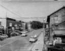
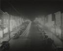
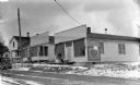
| Date: | 07 1956 |
|---|---|
| Description: | Elevated view looking east on Hubbard Street from the corner of Hubbard and Parmenter Streets. The old Schwab and Scwarz store, in the oldest building ... |
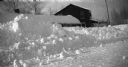
| Date: | 1937 |
|---|---|
| Description: | Winter scene with snow plowed high on County Road M, Clam Lake (Ashland Co.), Wisconsin. The Chippewa Tavern is visible in the background, and the building... |
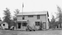
| Date: | 1936 |
|---|---|
| Description: | Two automobiles are parked next to a tavern with a Blatz Beer sign hanging out front. An American flag hangs from a flagpole. |
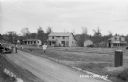
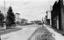
| Date: | 1935 |
|---|---|
| Description: | Elevated view across road of people and automobiles in front of homes and businesses along a dirt road. In the background is a local grocery store, tavern ... |

| Date: | 1942 |
|---|---|
| Description: | View up Silver Street in Hurley. |
| Date: | 08 02 1942 |
|---|---|
| Description: | Elevated view of Silver Street in Hurley at 4:30 a.m., Sunday morning, showing busy street and all establishment's lights blazing. After the sweeping raid ... |
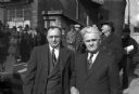
| Date: | 05 10 1947 |
|---|---|
| Description: | Mayor Vincent Totka of Cudahy and Mayor Charles Plotz of South Milwaukee pose for a photograph after greeting a CIO organized rally in South Milwaukee. A l... |
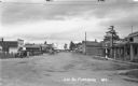
| Date: | 1939 |
|---|---|
| Description: | Automobiles and trucks parked along Main Street in Mercer. Storefront signs on the left side read: Sweet Shop, Drug, The Store, Coffee Shop, and Rugee's Me... |

| Date: | 1930 |
|---|---|
| Description: | Pen and ink map on paper of Wisconsin and northern Illinois showing stagecoach routes (marked in red) that traveled between Lake Michigan and the Mississip... |
| Date: | 1937 |
|---|---|
| Description: | View looking down middle of Main Street. Businesses from left to right include the U.S. Post Office, Tire & Battery Service, Store - Tourist & Supplies, St... |

| Date: | 1940 |
|---|---|
| Description: | A man removes a package from the back of an International D-15 truck owned by Atlas Linen Supply Company. The vehicle is parked along the curb in front of ... |
| Date: | 1937 |
|---|---|
| Description: | View across road of a man and a dog standing on the front stoop of a one-story building that has a sign that reads “Art’s Lunches and Confectionery, Ask fo... |
| Date: | 05 1972 |
|---|---|
| Description: | Spring scene on Wall Street. The building is the Arbutus Inn, hotel, bar and dining room. It was also the original Snowmobile Hall of Fame. Two boys are st... |

| Date: | 1975 |
|---|---|
| Description: | "Main (Milwaukee) Street. Six taverns were in business in the span of one block!" |
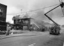
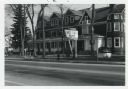
| Date: | 11 1991 |
|---|---|
| Description: | "With windchill factors below zero, firemen battled this fire at Das Pioneer Bier haus, operated by Mike Polster. Former proprietors were John Miller, Henr... |

| Date: | 1941 |
|---|---|
| Description: | This 1941 map covers Washburn County, Wisconsin, as well as western Sawyer, eastern Burnett, and northeastern Polk counties. It shows the locations of tour... |

| Date: | 11 1991 |
|---|---|
| Description: | Landmark tavern in Theresa demolished to make way for highway improvement plan. |
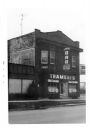
| Date: | 1974 |
|---|---|
| Description: | An exterior view of Trameri's Bar at 625 West Main Street. |

| Date: | 06 12 1929 |
|---|---|
| Description: | This manuscript blueprint shows buildings with the names of their owners, tabernacle, location "where Strang found plates" and "house where Strang died," a... |

| Date: | 1943 |
|---|---|
| Description: | This map shows roads, trails, taverns, schools, golf, gas stations, campsites, resorts, and towers. The lower left of the map includes a legend. The map co... |
If you didn't find the material you searched for, our Library Reference Staff can help.
Call our reference desk at 608-264-6535 or email us at: