 Filter: Categories of Wisconsin Historical Images
Filter: Subject of Surveying
Filter: Year of 1800-1899
Filter: Year of 1870-1879
Filter: Categories of Wisconsin Historical Images
Filter: Subject of Surveying
Filter: Year of 1800-1899
Filter: Year of 1870-1879

| Date: | 1876 |
|---|---|
| Description: | Made from U.S. Surveys and from minutes furnished by Jos. S. Buck and Dr. C. Chase. Scale 20 CHs to an inch. |

| Date: | 1874 |
|---|---|
| Description: | Map of New Diggings — inset map in bottom right corner of "Benton & New Diggings" map, on page 11 of "Atlas of Lafayette County Wisconsin," a collect... |

| Date: | 1875 |
|---|---|
| Description: | Map of the triangulations made from Vulcan on the Keweenaw Peninsula in the Upper Peninsula of Michigan south through eastern Wisconsin, past Chicago to Ba... |

| Date: | 1877 |
|---|---|
| Description: | A map of the triangulation and reconnaissance along the southwest corner of Wisconsin. The map shows the river systems, railroads, cities, and villages tha... |

| Date: | 1875 |
|---|---|
| Description: | These maps, from G.K. Warren's 1876 Report on the transportation route along the Wisconsin and Fox rivers in the State of Wisconsin between the Mississippi... |

| Date: | 1873 |
|---|---|
| Description: | This map shows lots and blocks, additions and subdivisions, and large-scale landownership. The map is oriented with north to the upper right. The map is fr... |
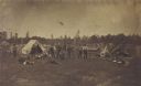
| Date: | 07 01 1871 |
|---|---|
| Description: | Railroad surveying party in camp somewhere north of Green Bay. The men were surveyors for the Chicago & Northwestern railroad extension. |

| Date: | 07 01 1875 |
|---|---|
| Description: | This map shows Lake Ontario, and a portion of Lake Erie and Oneida Lake. Towns surrounding these lakes in Canada and New York are labeled. A key to former ... |

| Date: | 07 01 1876 |
|---|---|
| Description: | This map shows Lake Ontario, and a portion of Lake Erie and Oneida Lake. Towns surrounding these lakes in Canada and New York are labeled. A key to former ... |

| Date: | 07 01 1876 |
|---|---|
| Description: | This map shows towns, railroads, and rivers in Ohio, Michigan, Pennsylvania, New York, and Ontario that surround Lake Erie. A key to completed and uncomple... |

| Date: | 1876 |
|---|---|
| Description: | This map shows eastern Wisconsin, Lake Michigan, western Michigan, northeastern Illinois, and the southern part of Lake Superior. A note is included that r... |
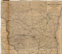
| Date: | 1879 |
|---|---|
| Description: | This map shows names of triangulation stations, railroads, counties, rivers, and lakes. The Mississippi River, Lake Winnebago, and Lake Michigan are labele... |
If you didn't find the material you searched for, our Library Reference Staff can help.
Call our reference desk at 608-264-6535 or email us at: