 Filter: Categories of Wisconsin Historical Images
Filter: Subject of Surveying
Filter: Year of 1800-1899
Filter: Categories of Wisconsin Historical Images
Filter: Subject of Surveying
Filter: Year of 1800-1899

| Date: | 1857 |
|---|---|
| Description: | This map depicts the township survey grid in Wisconsin, Michigan, northern Illinois, eastern Iowa, and southeastern Minnesota. Counties, named towns, citie... |

| Date: | 1857 |
|---|---|
| Description: | This map shows the township survey grid and identifies counties, named towns, cities and villages, rivers, lakes, and railroads. Boundaries are shown in bl... |

| Date: | 1859 |
|---|---|
| Description: | This map, which includes eastern Iowa and northern Illinois but omits the northern and northwestern tiers of counties in Wisconsin, shows the township surv... |

| Date: | 1864 |
|---|---|
| Description: | This map of the entire state of Wisconsin depicts the township survey grid and identifies counties, named towns, cities and villages, rivers, lakes, railro... |

| Date: | 1832 |
|---|---|
| Description: | A hand-drawn map showing the survey of Township number 4, Range number 5, West Fourth Principal Meridian, which is parts of the present day towns of Glen H... |

| Date: | 1836 |
|---|---|
| Description: | An ink on paper, hand-drawn map of the survey of the (Township No. 8, Range No. 16 East of the 4 Meridian) Town of Ixonia, Jefferson County, Wisconsin incl... |

| Date: | 1836 |
|---|---|
| Description: | This manuscript shows the 1835 survey of the road corresponding approximately to a portion of County Trunk A in the Town of Scott, Brown County, Wisconsin.... |

| Date: | 1875 |
|---|---|
| Description: | These maps, from G.K. Warren's 1876 Report on the transportation route along the Wisconsin and Fox rivers in the State of Wisconsin between the Mississippi... |

| Date: | 1850 |
|---|---|
| Description: | This 1850 survey by William H. Canfield shows the mounds near Wiegands Bay on the Wisconsin River in the Town of Merrimac, Sauk County, Wisconsin. |

| Date: | 1873 |
|---|---|
| Description: | This map shows lots and blocks, additions and subdivisions, and large-scale landownership. The map is oriented with north to the upper right. The map is fr... |
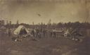
| Date: | 07 01 1871 |
|---|---|
| Description: | Railroad surveying party in camp somewhere north of Green Bay. The men were surveyors for the Chicago & Northwestern railroad extension. |

| Date: | 09 20 1836 |
|---|---|
| Description: | This map is ink and watercolor on paper and is an unnamed plat. Green Bay is labeled and the plat is labeled "Section 22." One road is labeled "Road to Nav... |

| Date: | 1882 |
|---|---|
| Description: | Plat map of the village of Dunbarton, received by the Lafayette County Register's Office on September 22, 1892. Certification by the surveyor, Albert Pool,... |
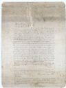
| Date: | 1882 |
|---|---|
| Description: | Note from Albert Pool, surveyor for the village of Dunbarton in Lafayette County, as appears on the reverse of the Village of Dunbarton plat map. Pool cert... |
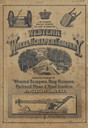
| Date: | 1886 |
|---|---|
| Description: | Front cover featuring illustrations of wheeled scrapers, drag scrapers, railroad plows and road graders. |

| Date: | 1836 |
|---|---|
| Description: | This map is ink and watercolor on paper and shows a plat of a paper city (a city planned but never built). Some streets and the Pekatolica River are labele... |

| Date: | 11 1836 |
|---|---|
| Description: | This map is pen-and-ink on paper and is a plat of a paper city on the Wisconsin River, in what is now the Town of Dekorra. The map shows lot and block numb... |

| Date: | 1899 |
|---|---|
| Description: | This map is ink on tracing cloth and shows lot and block numbers and dimensions, streets, the high school park, and survey monuments. The map is oriented ... |

| Date: | 1859 |
|---|---|
| Description: | This plat map is pen on paper and shows numbered blocks and lots, local streets, and section lines. Also included is text on survey certifications. |

| Date: | 1859 |
|---|---|
| Description: | This plat map is pen on paper and shows numbered blocks and lots, local streets, and section lines. Also included is text on survey certifications. The top... |
If you didn't find the material you searched for, our Library Reference Staff can help.
Call our reference desk at 608-264-6535 or email us at: