 Filter: Categories of Wisconsin Historical Images
Filter: Subject of Surveying
Filter: Subject of water
Filter: Categories of Wisconsin Historical Images
Filter: Subject of Surveying
Filter: Subject of water

| Date: | 1855 |
|---|---|
| Description: | This map shows the township survey grid and identifies counties, named towns, rivers, lakes, railroads, plank roads, mines, and the Menomonee Reservation. ... |

| Date: | 1857 |
|---|---|
| Description: | This map depicts the township survey grid in Wisconsin, Michigan, northern Illinois, eastern Iowa, and southeastern Minnesota. Counties, named towns, citie... |

| Date: | 1857 |
|---|---|
| Description: | This map shows the township survey grid and identifies counties, named towns, cities and villages, rivers, lakes, and railroads. Boundaries are shown in bl... |

| Date: | 1859 |
|---|---|
| Description: | This map, which includes eastern Iowa and northern Illinois but omits the northern and northwestern tiers of counties in Wisconsin, shows the township surv... |

| Date: | 1864 |
|---|---|
| Description: | This map of the entire state of Wisconsin depicts the township survey grid and identifies counties, named towns, cities and villages, rivers, lakes, railro... |

| Date: | 1836 |
|---|---|
| Description: | An ink on paper, hand-drawn map of the survey of the (Township No. 8, Range No. 16 East of the 4 Meridian) Town of Ixonia, Jefferson County, Wisconsin incl... |

| Date: | 1923 |
|---|---|
| Description: | This topographical map of Devil's Lake State Park, Sauk County, Wisconsin, is based on 1922-1923 surveys of the area by the University of Wisconsin Summer ... |
| Date: | 1906 |
|---|---|
| Description: | Portion of title: Eau Claire River, Wisconsin. Relief shown by contours and spot heights. Contour interval on land 5 feet. Contour interval on river surfac... |

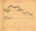
| Date: | 1875 |
|---|---|
| Description: | These maps, from G.K. Warren's 1876 Report on the transportation route along the Wisconsin and Fox rivers in the State of Wisconsin between the Mississippi... |

| Date: | 1850 |
|---|---|
| Description: | This 1850 survey by William H. Canfield shows the mounds near Wiegands Bay on the Wisconsin River in the Town of Merrimac, Sauk County, Wisconsin. |

| Date: | 1873 |
|---|---|
| Description: | This map shows lots and blocks, additions and subdivisions, and large-scale landownership. The map is oriented with north to the upper right. The map is fr... |

| Date: | 1918 |
|---|---|
| Description: | Outdoor view of a U.S. Army Engineer topographer wearing skis while in the process of surveying land. The engineer is standing next to a barbed wire obstac... |

| Date: | 1918 |
|---|---|
| Description: | Outdoor view of a U.S. Army Engineer topographer wearing skis while using a tripod stand to write. The engineer is standing next to a barbed wire obstacle ... |

| Date: | 1900 |
|---|---|
| Description: | A class of engineering students practicing surveying in front of Science Hall, located on the University of Wisconsin (Madison) campus. Eleven engineering ... |

| Date: | 1836 |
|---|---|
| Description: | This map is ink and watercolor on paper and shows a plat of a paper city (a city planned but never built). Some streets and the Pekatolica River are labele... |

| Date: | 11 1836 |
|---|---|
| Description: | This map is pen-and-ink on paper and is a plat of a paper city on the Wisconsin River, in what is now the Town of Dekorra. The map shows lot and block numb... |

| Date: | 1865 |
|---|---|
| Description: | This map shows the harbor with proposed extensions and the shore line as it appeared in 1865. Depths are shown by soundings. |

| Date: | 1930 |
|---|---|
| Description: | Original map made with watercolor and inkwash. Includes a legend of buildings, roads, natural features and other details of the lodge. Inset at bottom has ... |

| Date: | 1903 |
|---|---|
| Description: | This map shows lakes, rivers, railroads, and the soil types of towns and counties. A legend of soil types and conventional signs is included. Relief is sho... |

| Date: | 07 01 1875 |
|---|---|
| Description: | This map shows Lake Ontario, and a portion of Lake Erie and Oneida Lake. Towns surrounding these lakes in Canada and New York are labeled. A key to former ... |
If you didn't find the material you searched for, our Library Reference Staff can help.
Call our reference desk at 608-264-6535 or email us at: