 Filter: Categories of Wisconsin Historical Images
Filter: Subject of Surveying
Filter: Subject of streets
Filter: Categories of Wisconsin Historical Images
Filter: Subject of Surveying
Filter: Subject of streets

| Date: | 10 21 1855 |
|---|---|
| Description: | Map of the Wisconsin and the Minnesota Territory showing the status of township surveys in Wisconsin and southeastern Minnesota. The Wisconsin reservation... |

| Date: | 1873 |
|---|---|
| Description: | This map shows lots and blocks, additions and subdivisions, and large-scale landownership. The map is oriented with north to the upper right. The map is fr... |

| Date: | 02 02 1960 |
|---|---|
| Description: | The Madison Redevelopment Authority joined in the city's program of locating and permanently marking land survey corners in the Madison area. Here they mar... |

| Date: | 1882 |
|---|---|
| Description: | Plat map of the village of Dunbarton, received by the Lafayette County Register's Office on September 22, 1892. Certification by the surveyor, Albert Pool,... |

| Date: | 1836 |
|---|---|
| Description: | This map is ink and watercolor on paper and shows a plat of a paper city (a city planned but never built). Some streets and the Pekatolica River are labele... |

| Date: | 11 1836 |
|---|---|
| Description: | This map is pen-and-ink on paper and is a plat of a paper city on the Wisconsin River, in what is now the Town of Dekorra. The map shows lot and block numb... |

| Date: | 1899 |
|---|---|
| Description: | This map is ink on tracing cloth and shows lot and block numbers and dimensions, streets, the high school park, and survey monuments. The map is oriented ... |

| Date: | 1859 |
|---|---|
| Description: | This plat map is pen on paper and shows numbered blocks and lots, local streets, and section lines. Also included is text on survey certifications. |

| Date: | 1859 |
|---|---|
| Description: | This plat map is pen on paper and shows numbered blocks and lots, local streets, and section lines. Also included is text on survey certifications. The top... |

| Date: | 1919 |
|---|---|
| Description: | Surveyor's drawings of William Deerings Agricultural Works in Lake View, Illinois erected in 1880. |
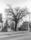
| Date: | 1981 |
|---|---|
| Description: | View across street towards a very tall bur oak towering over nearby houses at the corner of Main and Franklin Streets. There is a small monument at its bas... |

| Date: | 1880 |
|---|---|
| Description: | A map of Milwaukee which includes a city street guide. |
If you didn't find the material you searched for, our Library Reference Staff can help.
Call our reference desk at 608-264-6535 or email us at: