 Filter: Categories of Wisconsin Historical Images
Filter: Subject of Surveying
Filter: Subject of service industries
Filter: Categories of Wisconsin Historical Images
Filter: Subject of Surveying
Filter: Subject of service industries

| Date: | 1911 |
|---|---|
| Description: | Workers erecting a steam driven pile driver while others survey for the railroad extension from the village of Prairie du Sac to the dam site on the Wiscon... |
| Date: | |
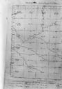
|---|---|
| Description: | Map, "Township No. 22 North, of Range No. 5 West of (?)," surveyed in 1846 and 1853. |

| Date: | 02 02 1960 |
|---|---|
| Description: | The Madison Redevelopment Authority joined in the city's program of locating and permanently marking land survey corners in the Madison area. Here they mar... |

| Date: | 1930 |
|---|---|
| Description: | Original map made with watercolor and inkwash. Includes a legend of buildings, roads, natural features and other details of the lodge. Inset at bottom has ... |
If you didn't find the material you searched for, our Library Reference Staff can help.
Call our reference desk at 608-264-6535 or email us at: