Filter: Categories of Wisconsin Historical Images
Filter: Subject of Surveying
Filter: Subject of land use
Filter: Categories of Wisconsin Historical Images
Filter: Subject of Surveying
Filter: Subject of land use

| Date: | 1969 |
|---|---|
| Description: | A surveyor conducts work at the construction of the World Trade Center. He is at work before the building located at 210 Washington Street. |
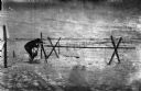
| Date: | 1969 |
|---|---|
| Description: | Five men surveying land across a road. They're standing near a barbed wire fence. |
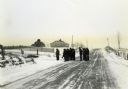
| Date: | |
|---|---|
| Description: | Wisconsin Land Economic Inventory mapping crew starting out in the snow for instruction. |

| Date: | 04 1937 |
|---|---|
| Description: | From back of print: "Dane County, Town of Middleton, north 1/2 section of section 17 looking SW from a hill across the valley showing erosion and stump pas... |

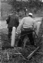
| Date: | 1911 |
|---|---|
| Description: | Workers erecting a steam driven pile driver while others survey for the railroad extension from the village of Prairie du Sac to the dam site on the Wiscon... |
| Date: | 1920 |
|---|---|
| Description: | A.L. Webster takes notes in a notebook while using tools to do surveying work in a field. Another man stands holding a rod in the background near what appe... |
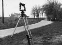
| Date: | 1970 |
|---|---|
| Description: | "Surveying Crew on McArthur Rd. Sunny Brae farm is in background." |

| Date: | 1850 |
|---|---|
| Description: | This 1850 survey by William H. Canfield shows the mounds near Wiegands Bay on the Wisconsin River in the Town of Merrimac, Sauk County, Wisconsin. |
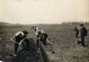
| Date: | |
|---|---|
| Description: | View of a crew surveying land, digging a ditch, and laying drain tile. |
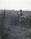
| Date: | 1918 |
|---|---|
| Description: | Outdoor view of a U.S. Army Engineer topographer wearing skis while in the process of surveying land. The engineer is standing next to a barbed wire obstac... |

| Date: | 1918 |
|---|---|
| Description: | Outdoor view of a U.S. Army Engineer topographer wearing skis while using a tripod stand to write. The engineer is standing next to a barbed wire obstacle ... |

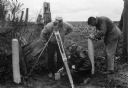
| Date: | 02 02 1960 |
|---|---|
| Description: | The Madison Redevelopment Authority joined in the city's program of locating and permanently marking land survey corners in the Madison area. Here they mar... |

| Date: | 1882 |
|---|---|
| Description: | Plat map of the village of Dunbarton, received by the Lafayette County Register's Office on September 22, 1892. Certification by the surveyor, Albert Pool,... |

| Date: | 1900 |
|---|---|
| Description: | A class of engineering students practicing surveying in front of Science Hall, located on the University of Wisconsin (Madison) campus. Eleven engineering ... |

| Date: | 1850 |
|---|---|
| Description: | Diagrams of four effigy mounds surveyed by Increase A. Lapham and W.H. Canfield in 1850. No. 1 is an unidentified animal shape, No. 2 consists of two linea... |

| Date: | 1880 |
|---|---|
| Description: | A map of Milwaukee which includes a city street guide. |
If you didn't find the material you searched for, our Library Reference Staff can help.
Call our reference desk at 608-264-6535 or email us at: