 Filter: Categories of Wisconsin Historical Images
Filter: Subject of Superior, Lake
Filter: Year of 1900-1999
Filter: County of Bayfield
Filter: Subject of transportation
Filter: Categories of Wisconsin Historical Images
Filter: Subject of Superior, Lake
Filter: Year of 1900-1999
Filter: County of Bayfield
Filter: Subject of transportation
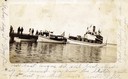
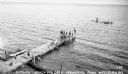
| Date: | 1912 |
|---|---|
| Description: | Boats and people at the Bayfield dock on Labor Day 1912. Boats include Thelma; Lusitania; which later became a U.S. Mail boat; Captain Angus'... |

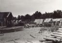
| Date: | 1910 |
|---|---|
| Description: | Bird's-eye view looking east, with Washburn Harbor at center and Chequamegon Bay in Lake Superior covering most of the upper image. Streets with buildings... |
| Date: | 1915 |
|---|---|
| Description: | Building, boats, and fish net drying reels on South Twin Island in the Apostle Islands archipelago. |
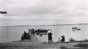
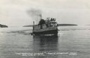
| Date: | 1910 |
|---|---|
| Description: | View towards shoreline of an automobile being driven on the Bayfield City Dock. Colonel Woods' boat, "Nebraska" is at the dock. Sam Fifields' "Stella" is a... |
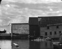
| Date: | 1969 |
|---|---|
| Description: | View from water of the sides of three wharf buildings in a bay of Lake Superior. |
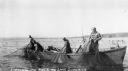
| Date: | 1937 |
|---|---|
| Description: | Four men in a large row boat lifting fishing nets on Lake Superior near Cornucopia. |
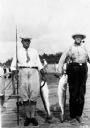
| Date: | 1937 |
|---|---|
| Description: | Two men standing on dock each holding a lake trout. |
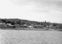
| Date: | 1942 |
|---|---|
| Description: | View from Lake Superior looking at the shoreline of Washburn. Houses, buildings, people, cars and trees are visible on shore. |
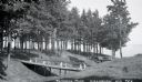
| Date: | 1932 |
|---|---|
| Description: | View of two wooden foot bridges in Memorial Park. In the background are the waters of Chequamegon Bay in Lake Superior. Picnic tables are among the trees. ... |
| Date: | 1935 |
|---|---|
| Description: | Boys and girls wearing bathing suits standing, swimming, or diving off of a large wooden dock into Chequamegon Bay, Lake Superior on the beach at Memorial ... |
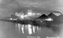
| Date: | 1936 |
|---|---|
| Description: | Unloading coal from a large ship in Lake Superior onto land near Washburn. There is a large conveyor that has lights glowing in the dark sky. A large pile ... |
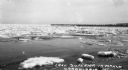
| Date: | 03 1935 |
|---|---|
| Description: | View taken from shore of ice chunks in Lake Superior near Cornucopia while the ice is melting. In the background along the shoreline is a long pier. |

| Date: | 1931 |
|---|---|
| Description: | View of the Squaw Bay Caves, near Cornucopia, with people in a boat off to the far left. The caves were renamed Mawikwe Bay, and Mawikwe is Ojibwe for weep... |

| Date: | 1952 |
|---|---|
| Description: | This 1952 map of the northern parts of Bayfield and Douglas counties, Wisconsin, shows points established by E.T. Sweet in 1877, road points confirmed by S... |

| Date: | 1917 |
|---|---|
| Description: | This 1917 map of Bayfield County, Wisconsin, shows the township and range system, towns, sections, cities and villages, railroads, wagon roads, and lakes a... |

| Date: | 1935 |
|---|---|
| Description: | This pictorial map of northern Bayfield County, Wisconsin, shows the Chequamegon National Forest, the Red Cliff Indian Reservation, highways and roads, and... |

| Date: | 1906 |
|---|---|
| Description: | This 1906 map of Bayfield County, Wisconsin, shows towns, sections, cities, villages and post offices, land ownership, wagon roads, railroads, schools, gov... |

| Date: | 1967 |
|---|---|
| Description: | This tourist brochure for Bayfield County, Wisconsin, from 1967 includes a map of the county showing towns, cities and villages, highways and roads, railro... |
| Date: | 1950 |
|---|---|
| Description: | Photographic postcard view of a fishing boat in Lake Superior with tourists on board. There is an island on the horizon. Caption reads: "'The Apostle Isla... |
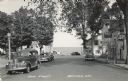
| Date: | 1950 |
|---|---|
| Description: | Photographic postcard view down Main Street, with Lake Superior in the distance. There is a cafe on the left and bars on the right. Cars are parked along t... |
If you didn't find the material you searched for, our Library Reference Staff can help.
Call our reference desk at 608-264-6535 or email us at: