 Filter: Categories of Wisconsin Historical Images
Filter: Subject of Superior, Lake
Filter: Subject of michigan, lake
Filter: Year of 1800-1899
Filter: Year of 1890-1899
Filter: Categories of Wisconsin Historical Images
Filter: Subject of Superior, Lake
Filter: Subject of michigan, lake
Filter: Year of 1800-1899
Filter: Year of 1890-1899

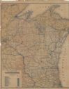
| Date: | 1898 |
|---|---|
| Description: | Shows railway lines in Wisconsin marked in red and counties in colors. The meridians are Greenwich, Wisconsin and Washington, Wisconsin. The map folds into... |

| Date: | 1890 |
|---|---|
| Description: | This map shows lakes, railroads, and rivers. An explanation of railroad lines with mileage in Wisconsin and total mileage for 1890 is included. Portions of... |

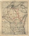
| Date: | 1892 |
|---|---|
| Description: | A cloth mounted, hand-colored map of Wisconsin showing the rail routes, counties, cities, towns, rivers and lakes in the state. The map also shows eastern ... |

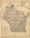
| Date: | 1896 |
|---|---|
| Description: | This hand-colored map shows counties, county seats, cities, towns, proposed and completed railroads, and U.S. Land Offices. Also included in the map are th... |

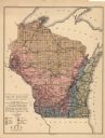
| Date: | 1895 |
|---|---|
| Description: | A map of Wisconsin that shows the counties, cities, towns, rivers, and lakes of the state, the eastern most portions of Minnesota, Iowa, northern Illinois,... |

| Date: | 1899 |
|---|---|
| Description: | This color map, originally published in the Smithsonian Institution Bureau of American Ethnology's 18th annual report, shows the Indian land cessions in Wi... |

| Date: | 1896 |
|---|---|
| Description: | A map showing the Wisconsin Central Railroad lines in Wisconsin, northern Illinois, eastern Minnesota, and Michigan’s Upper Peninsula. The area of the map ... |

| Date: | 1890 |
|---|---|
| Description: | A map of Wisconsin, eastern Wisconsin and Iowa, northern Illinois, and the Upper Peninsula of Michigan. The counties, cities and villages, and rail lines i... |

| Date: | 1898 |
|---|---|
| Description: | A hand-colored, cloth mounted map of Wisconsin showing the state’s congressional districts. The map also shows the counties, cities, towns, villages, river... |

| Date: | 1899 |
|---|---|
| Description: | This map is a folded insert from the pamphlet "Yesterday and Today : A History." The map features the North-Western Line with labeled railway tracks and st... |

| Date: | 1890 |
|---|---|
| Description: | This map shows railroad routes, rivers, and lakes throughout the north central states, primarily North and South Dakota, Minnesota, Wisconsin, Illinois, Io... |

| Date: | 1896 |
|---|---|
| Description: | This map shows railroad routes in red, blue, orange, brown, pink, green, and dotted, as well as lakes, rivers, and communities. The map includes a legend i... |
| Date: | 1898 |
|---|---|
| Description: | This map shows railroad routes in red, blue, orange, brown, pink, green, and dotted, as well as lakes, rivers, and communities. The map includes a legend i... |
| Date: | 1892 |
|---|---|
| Description: | This map shows railroad routes. County boundaries, towns, rivers, lakes, Lake Michigan and Superior are also labeled. The upper margin includes a color leg... |

| Date: | 1896 |
|---|---|
| Description: | This map shows the railroad routes of the Wisconsin Central Railroad and its land grant. These are visibly marked in the color red. County boundaries are a... |
| Date: | 1897 |
|---|---|
| Description: | This map shows the location of quarries throughout the state. Original caption reads, "Geology taken from General Geological Map of Wisconsin by the First ... |
| Date: | 1897 |
|---|---|
| Description: | This map shows the location of quarries throughout the state. Original caption reads, "Geology taken from General Geological Map of Wisconsin by the First ... |

| Date: | 1898 |
|---|---|
| Description: | This map shows the conditions of the forest. Includes a color legend in left margin, depicting the various conditions. Original caption reads, "Compiled by... |

| Date: | 1899 |
|---|---|
| Description: | This map shows color coded and numbered regions of Indian land cessions. Lake Superior and Lake Michigan are labeled and other lakes and rivers are shown. ... |

| Date: | 1899 |
|---|---|
| Description: | This map shows color coded and numbered regions of Indian land cessions. Lake Superior and Lake Michigan are labeled and other lakes and rivers are shown. ... |
If you didn't find the material you searched for, our Library Reference Staff can help.
Call our reference desk at 608-264-6535 or email us at: