 Filter: Categories of Wisconsin Historical Images
Filter: Subject of Superior, Lake
Filter: Subject of land use
Filter: Categories of Wisconsin Historical Images
Filter: Subject of Superior, Lake
Filter: Subject of land use

| Date: | 1910 |
|---|---|
| Description: | View of La Pointe taken from Big Bay Road on Madeline Island. |

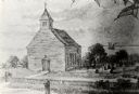
| Date: | 1898 |
|---|---|
| Description: | Old Mission Residence at La Pointe, Madeline Island. |

| Date: | 1850 |
|---|---|
| Description: | Pastoral scene depicting a small bay on the Island of St. Ignace in Lake Superior with canoes on the rocky beach, two men conversing on a blanket in the fo... |

| Date: | 1890 |
|---|---|
| Description: | Bird's-eye map of West Superior and Superior, with insets of Wright Farm and First Building in Superior. |
| Date: | 1870 |
|---|---|
| Description: | One of the etchings published in an atlas of Lake County, Illinios in 1870 by George Ogle. Etchings done by the Wisconsin Central Railroad. |
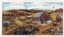
| Date: | |
|---|---|
| Description: | An auctioneer, a clerk, and a helper stand on a stage on a farm conducting an auction as potential bidders surround them. Farming equipment and other items... |
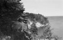
| Date: | 1934 |
|---|---|
| Description: | Man on Madeline Island cliff overlooking Lake Superior. |

| Date: | 1937 |
|---|---|
| Description: | Two-story house with an enclosed front porch, built in 1929 on the northwest shore of Madeline Island. |

| Date: | 1881 |
|---|---|
| Description: | A brochure with a map of Wisconsin that also includes information (in English, German, Norwegian, and Swedish) pertaining to the state, such as its timber ... |

| Date: | 1916 |
|---|---|
| Description: | In 1916, it was estimated that 15,000 Indian mounds had formerly existed in Wisconsin. In the early 20th century, the Wisconsin Archaeological Society surv... |

| Date: | 1854 |
|---|---|
| Description: | Brightly-colored map exhaustively marks the townships, County Towns and villages of Wisconsin. It also shows rivers, canals, railroads, and plank roads. Ea... |

| Date: | 1855 |
|---|---|
| Description: | Drawn seven years after Wisconsin entered statehood, this map shows the counties, cities, towns, rivers and lakes in the entire state. The map includes a c... |

| Date: | 1952 |
|---|---|
| Description: | This map shows counties, towns, cities, and selected villages, as well as the Menominee Indian Reservation are identified on this U.S. Post Office. Circles... |

| Date: | 1872 |
|---|---|
| Description: | This map, which includes eastern Iowa, northern Illinois and a portion of Michigan's Upper peninsula, shows the township survey grid and identifies countie... |

| Date: | 1960 |
|---|---|
| Description: | This mid-20th century tourist brochure for Bayfield County, Wisconsin, includes a map of the county showing towns, cities and villages, highways and roads,... |

| Date: | 1934 |
|---|---|
| Description: | This map shows industrial points of interest in Superior. The top of the map reads: "Superior, Douglas County, Wisconsin, as this Industrial Tour map indic... |

| Date: | 1861 |
|---|---|
| Description: | This map shows lot and block numbers, piers, streets, monuments, and township section corners. Included is a note on the width of avenues, piers, slips, al... |

| Date: | 1939 |
|---|---|
| Description: | This illustrated map shows counties, highways, rivers, roads, present and proposed state parks and forests, proposed state parkways, proposed state monumen... |

| Date: | 1996 |
|---|---|
| Description: | This map shows roads, lakes, points of interest including colleges, trails, historic communities and sites, museums, and parks. Also included are descripti... |

| Date: | 1919 |
|---|---|
| Description: | Narrow red lines show principal secondary highways. Green circles shows points of historical interest. Green triangles show Indian mounds and Indian villag... |
If you didn't find the material you searched for, our Library Reference Staff can help.
Call our reference desk at 608-264-6535 or email us at: