 Filter: Categories of Wisconsin Historical Images
Filter: Subject of Superior, Lake
Filter: Subject of land
Filter: Categories of Wisconsin Historical Images
Filter: Subject of Superior, Lake
Filter: Subject of land
| Date: | 1838 |
|---|---|
| Description: | Map of the entire territories of Iowa and Wisconsin. |
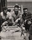
| Date: | 1955 |
|---|---|
| Description: | Catch of lake trout displayed by three fisherman on the pier at Little Sand Bay. From left to right are Martin Johnson, Hermy Johnson, and Myron Lohman. |
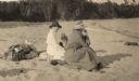
| Date: | 1920 |
|---|---|
| Description: | Mrs. Cora Hull & Mrs. Julia Wood are seated on the sandy shore of one of the Apostle Islands overlooking Lake Superior. |

| Date: | 1890 |
|---|---|
| Description: | This map shows lakes, railroads, and rivers. An explanation of railroad lines with mileage in Wisconsin and total mileage for 1890 is included. Portions of... |
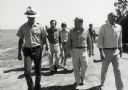
| Date: | 1979 |
|---|---|
| Description: | Senator Gaylord Nelson, Dave Obey, and Secretary of the Interior Cecil Andrus, walk along a beach with a park ranger during a tour of the Apostle Islands. ... |

| Date: | 1914 |
|---|---|
| Description: | Four individuals, sitting in the shade near a table during a picnic on Madeline Island. Includes Elizabeth Nesbet (Mrs. S.C. Marty, Sr.), Gertrude Capser (... |

| Date: | 1820 |
|---|---|
| Description: | Map of the Northwestern Territories of the United State showing the track pursued by the Expedition in 1820. |
| Date: | 1820 |
|---|---|
| Description: | Narrative Journal of Travels from Detroit Northwest through the Great chain of American Lakes to the sources of the Mississippi River in the year 1820. Ill... |

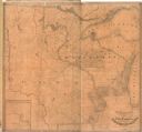
| Date: | 1884 |
|---|---|
| Description: | The official railroad map of Wisconsin showing railroad lines throughout the state. |

| Date: | 1878 |
|---|---|
| Description: | A color map detailing Ashland and Bayfield counties, including Lake Superior and the Apostle Islands. |
| Date: | 1933 |
|---|---|
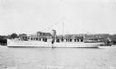
| Description: | View across water of the motor yacht "The Nellewood" at dock at Madeline Island on Lake Superior. A group of passengers sit in the bow area. The "Nellewood... |
| Date: | 1934 |
|---|---|
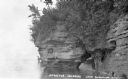
| Description: | View across water of sandstone cliff shoreline along Lake Superior at the Apostle Islands. On the far right a boat is pulled up onshore, and painted on the... |
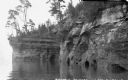
| Date: | 1934 |
|---|---|
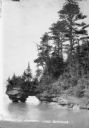
| Description: | View across water of trees and plants covering a sandstone cliff and arch on the shoreline along Lake Superior. Another sandstone arch is in the far backgr... |
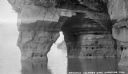
| Date: | 1934 |
|---|---|
| Description: | View from water of sandstone cliffs and caves on Lake Superior shoreline. |
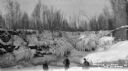
| Date: | 1934 |
|---|---|
| Description: | Three men standing on frozen Lake Superior in front of ice covered shoreline. |
| Date: | 1934 |
|---|---|
| Description: | View from water of sandstone shoreline on south shore of Lake Superior. |
| Date: | 1934 |
|---|---|
| Description: | View from water of Devil's Island lighthouse located above sandstone caves and arches in the Apostle Islands of Lake Superior. Caption reads: "Devil's Isla... |
| Date: | 1935 |
|---|---|
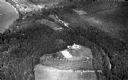
| Description: | Aerial view of Madeline Island including the tennis courts, houses, and the Old Mission Inn. |
| Date: | 1934 |
|---|---|
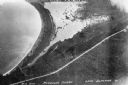
| Description: | Aerial view of Big Bay on Madeline Island. This area later became Big Bay State Park. |
| Date: | 1934 |
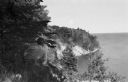
|---|---|
| Description: | Man on Madeline Island cliff overlooking Lake Superior. |
If you didn't find the material you searched for, our Library Reference Staff can help.
Call our reference desk at 608-264-6535 or email us at: