 Filter: Categories of Wisconsin Historical Images
Filter: Subject of Superior, Lake
Filter: Subject of land
Filter: Subject of lakes
Filter: Categories of Wisconsin Historical Images
Filter: Subject of Superior, Lake
Filter: Subject of land
Filter: Subject of lakes
| Date: | 1887 |
|---|---|
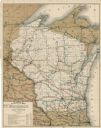
| Description: | This map shows lakes, railroads, and rivers. An explanation of railroad lines with mileage in Wisconsin and total mileage for 1887 is included. Portions of... |
| Date: | 1889 |
|---|---|
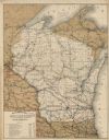
| Description: | This map shows lakes, railroads, and rivers. An explanation of railroad lines with mileage in Wisconsin and total mileage for 1889 is included. Portions of... |

| Date: | 1851 |
|---|---|
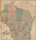
| Description: | This map shows townships, villages, Indian villages, railroads, roads, mills, prairies, swamps, and canals. An inset map shows a plat of the copper distric... |

| Date: | 1916 |
|---|---|
| Description: | This map shows highways, roads, routes, communities, rivers, and lakes. Wide red lines show principle highways. Narrow red lines show secondary roadways or... |

| Date: | 1925 |
|---|---|
| Description: | This map shows the state trunk highway system and county trunk highways. The lower left corner includes a legend of roadway types. Lake Michigan and Lake S... |

| Date: | 1928 |
|---|---|
| Description: | This map shows the state trunk highway system and county trunk highways. The lower left corner includes a legend of roadway types. Lake Michigan and Lake S... |

| Date: | 1920 |
|---|---|
| Description: | This blueprint map covers the boundary area between Lake Superior and the Lac Vieux Desert. The map reads: "Land lines, streams, lakes, railroads, cities a... |

| Date: | 1900 |
|---|---|
| Description: | This map shows railroad routes in red, blue, orange, brown, pink, green, and dotted, as well as lakes, rivers, and communities. The map includes a legend i... |

| Date: | 1989 |
|---|---|
| Description: | This color coded map shows the various rivers, lakes, bays, and islands that make up the harbor. It includes an index of industries (maritime and non-marit... |
| Date: | 1876 |
|---|---|
| Description: | This map shows mileages between rivers, lakes, and portages in Northern Wisconsin. Lake Superior is visible at the top of the map. Original caption reads, ... |
| Date: | 1868 |
|---|---|
| Description: | This map shows railroads, counties and towns and includes a township grid. Sections are shown in blue, green, yellow, and pink. Rivers and lakes are labele... |

| Date: | 1868 |
|---|---|
| Description: | This map shows the configurations of the counties, communities, railroads and projected railroads, mines, shipping routes, and labeled rivers and lakes. Po... |

| Date: | 1898 |
|---|---|
| Description: | This map shows the conditions of the forest. Includes a color legend in left margin, depicting the various conditions. Original caption reads, "Compiled by... |

| Date: | 1831 |
|---|---|
| Description: | This map shows the land that makes up Michigan, Wisconsin, Minnesota, Indiana, and parts of Canada. The Great Lakes are displayed prominently, along with s... |

| Date: | 1947 |
|---|---|
| Description: | This map shows the territories of Chippewa, Sioux, Winnebago, and Monomone tribes. It also shows navigation notes for rivers and lakes, Indian villages, hi... |

| Date: | 1920 |
|---|---|
| Description: | This blue line print map shows land claimed by the state and land claimed by Michigan, including disputed areas between the Branch River and Brule Lake and... |

| Date: | 1920 |
|---|---|
| Description: | This map represents around 1841 and shows Lake Superior, other lakes, rivers, bays, and the border between Michigan and Wisconsin. There are annotations in... |

| Date: | 1696 |
|---|---|
| Description: | This sea chart and topographical map depicts the north east coast of Canada and North America, focusing on the Hudson Bay and Great Lakes regions. It shows... |

| Date: | 1777 |
|---|---|
| Description: | This detailed map of the American colonies shows cities, villages, roads, mountains, lakes, rivers, swamps, counties, state boundaries, and Native American... |

| Date: | 1690 |
|---|---|
| Description: | A mysterious mixture of mythology, ancient geography, and late 17th century knowledge of the American coastline. This map shows North and South America, bu... |
If you didn't find the material you searched for, our Library Reference Staff can help.
Call our reference desk at 608-264-6535 or email us at: