 Filter: Categories of Wisconsin Historical Images
Filter: Subject of Superior, Lake
Filter: Subject of land
Filter: Subject of intellectual life
Filter: Categories of Wisconsin Historical Images
Filter: Subject of Superior, Lake
Filter: Subject of land
Filter: Subject of intellectual life
| Date: | 1925 |
|---|---|
| Description: | Aerial view of Woods' Manor on shores of Madeline Island. The manor was built in 1900 for summer resident Colonel Frederick Woods from Nebraska. |

| Date: | 1886 |
|---|---|
| Description: | Bird's-eye view of Ashland, on the shores of Lake Superior, with insets of The Apostle Islands Chequamagon Bay & Ashland, and Distances from Ashland. |

| Date: | 1890 |
|---|---|
| Description: | Bird's-eye map of Ashland, viewed from Lake Superior, with insets of Prentice Park and Fishery. Population 16,000. Increase in Ten Years, 11,000. |

| Date: | 1886 |
|---|---|
| Description: | Bird's-eye view of Bayfield, county seat of Bayfield County. On the lower left side is an inset for Bayfield and the Apostle Islands. |

| Date: | 1883 |
|---|---|
| Description: | Bird's-eye map of Superior, county seat of Douglas County, on the shores of Lake Superior, with insets of points of interest. |

| Date: | 1915 |
|---|---|
| Description: | Bird's-eye view of Superior, Wisconsin, and Duluth, Minnesota on opposite shore of Lake Superior. |

| Date: | 1886 |
|---|---|
| Description: | Bird's-eye map of Washburn on Lake Superior. There is an inset of Washburn, Chequamagon and the Apostle Islands. |

| Date: | 1910 |
|---|---|
| Description: | Bird's-eye view looking east, with Washburn Harbor at center and Chequamegon Bay in Lake Superior covering most of the upper image. Streets with buildings... |

| Date: | 02 26 1887 |
|---|---|
| Description: | Bird's-eye map of Ashland, and the Apostle Islands in Lake Superior. Caption reads: "Ashland and the Apostle Islands." |

| Date: | 1884 |
|---|---|
| Description: | Panorama bird's-eye view of the town of Ashland, on Lake Superior, and the Apostle Islands. |

| Date: | 1960 |
|---|---|
| Description: | Aerial view with docks in the foreground. Caption reads: "Superior, Wisconsin." |

| Date: | 1865 |
|---|---|
| Description: | Map showing the location of meteorological stations and effects that Lake Michigan has had on Wisconsin temperatures in January and July. The map shows cou... |

| Date: | 1820 |
|---|---|
| Description: | Map of the Northwestern Territories of the United State showing the track pursued by the Expedition in 1820. |
| Date: | 1935 |
|---|---|
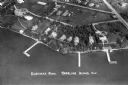
| Description: | Aerial view of Madeline Island including the tennis courts, houses, and the Old Mission Inn. |
| Date: | 1934 |
|---|---|
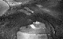
| Description: | Aerial view of Big Bay on Madeline Island. This area later became Big Bay State Park. |
| Date: | 1937 |
|---|---|
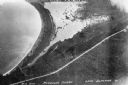
| Description: | Aerial view of Nebraska Row on the lakeshore of the west side of La Pointe, showing houses, roads and piers. Nebraska Row was started in 1899 when summer r... |

| Date: | 1919 |
|---|---|
| Description: | This map depicts the route of the 1842 overland trip by wagon made by the Reverend Alfred Brunson and some copper miners from Prairie du Chien to the mouth... |
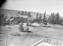
| Date: | 1938 |
|---|---|
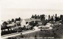
| Description: | Aerial view looking down over the lawn and wood shingle lakeshore home, Woods Manor, a part of Nebraska Row on Madeline Island. In the distance is Lake Sup... |

| Date: | |
|---|---|
| Description: | Aerial view of town, showing the shoreline of Lake Superior, ore docks, roads, houses, buildings, trees, and smokestacks. Text describing this photograph s... |

| Date: | 1916 |
|---|---|
| Description: | In 1916, it was estimated that 15,000 Indian mounds had formerly existed in Wisconsin. In the early 20th century, the Wisconsin Archaeological Society surv... |
If you didn't find the material you searched for, our Library Reference Staff can help.
Call our reference desk at 608-264-6535 or email us at: