 Filter: Categories of Wisconsin Historical Images
Filter: Subject of Superior, Lake
Filter: Creator Name of Unknown
Filter: Categories of Wisconsin Historical Images
Filter: Subject of Superior, Lake
Filter: Creator Name of Unknown

| Date: | 1920 |
|---|---|
| Description: | This map represents around 1841 and shows Lake Superior, other lakes, rivers, bays, and the border between Michigan and Wisconsin. There are annotations in... |

| Date: | 1922 |
|---|---|
| Description: | This map shows public libraries, state traveling libraries, and county traveling libraries. County boundaries are labeled. Lake Michigan is on the far righ... |

| Date: | 1930 |
|---|---|
| Description: | This map shows surface types on the highways including: concrete, bit, mat, gravels, shales, and unsurfaced. County boundaries, cities, rivers, roads, high... |

| Date: | 1910 |
|---|---|
| Description: | This map shows the Soo Line railroad and Arpin Hardwood Lumber Company lands in red. The top margin of the map reads: "Wisconsin, the safest state in the U... |
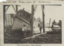
| Date: | 11 29 1908 |
|---|---|
| Description: | Men working on pulling the boat "Fish Hawk" out of the water. One man is kneeling in front of the boat and looking at the camera. A man in the background i... |

| Date: | 1683 |
|---|---|
| Description: | Map of the north east coast of North America showing islands, regions, Native American land, bays, and a few European settlements. The Great Lakes appear i... |

| Date: | 1720 |
|---|---|
| Description: | Map showing the course of the Mississippi River from the Gulf of Mexico up past Lake Superior into Canada. It shows the towns, Native American tribes and l... |

| Date: | 1755 |
|---|---|
| Description: | Map of the Great Lakes region during the French and Indian War. It shows in great detail the territories, borders and boundary lines, Native American tribe... |

| Date: | |
|---|---|
| Description: | View across water towards a cargo ship at dock in front of large grain elevators. |

| Date: | |
|---|---|
| Description: | Two women and a man are walking down the dock near a boat named "Chippewa" on Rocky Island.c South Twin Island is across the water in the background. |
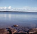
| Date: | |
|---|---|
| Description: | View from rocky shoreline of towards one of the Apostle Islands across the water. |

| Date: | |
|---|---|
| Description: | A map of the Apostle Islands, including the harbor of Bayfield and its surroundings. |
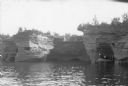
| Date: | 1920 |
|---|---|
| Description: | View across water towards three men and a woman posing while standing in a wooden boat in a sea cave in the Apostle Islands. Rock formations and other sea ... |

| Date: | 1940 |
|---|---|
| Description: | The moon, partially obstructed by clouds, is reflected in the waters off one of the Apostle Islands. There is a small islet on the right, with several tree... |

| Date: | |
|---|---|
| Description: | View across water towards the "Gar How." A group of people are on the boat. |
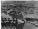
| Date: | 05 09 1943 |
|---|---|
| Description: | Composite photograph of the Dionne Quintuplets and the five ships they launched at the Walter Shipbuilding Company. An inset of Yvonne, Annette, Émilie, Cé... |

| Date: | |
|---|---|
| Description: | Outdoor group portrait of men, women, and children. Title reads: "A bunch of natives, head of Lake Superior, Chippewas, Irish & Dutch." |

| Date: | 1854 |
|---|---|
| Description: | A sketch of the public surveys of Wisconsin and territory of Minnesota. |
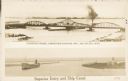
| Date: | 1907 |
|---|---|
| Description: | Postcard with two images. The top text reads: "Interstate Bridge, connecting Superior, Wis. and Duluth, Minn." The bottom text reads: "Superior Entry and S... |
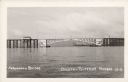
| Date: | 1942 |
|---|---|
| Description: | Text on front reads: "Arrowhead Bridge, Duluth-Superior Harbor. The bridge connected Superior, Wisconsin, with Duluth, Minnesota, over the St. Louis River.... |
If you didn't find the material you searched for, our Library Reference Staff can help.
Call our reference desk at 608-264-6535 or email us at: