 Filter: Categories of Wisconsin Historical Images
Filter: Subject of Streets
Filter: Subject of business
Filter: Categories of Wisconsin Historical Images
Filter: Subject of Streets
Filter: Subject of business
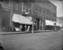
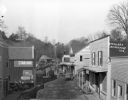
| Date: | 1900 |
|---|---|
| Description: | Families gathered outside of Werner's Drugstore on annuity pay day. A sign reads "Medicine sold here" in Ho-Chunk, German, and Norwegian. The Ho-Chunk syll... |
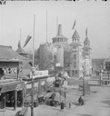
| Date: | 1893 |
|---|---|
| Description: | Columbian Exposition; North side of Midway Pleasance viewed from Madison Avenue. |
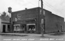
| Date: | |
|---|---|
| Description: | Exterior view of Tucker's Rexall Drugstore. Winter's watertower is in the background. |
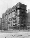
| Date: | 1902 |
|---|---|
| Description: | International Harvester's first headquarters building at 7 Monroe Street on the northwest corner of Michigan Avenue. IHC later sold the building and proper... |

| Date: | 1890 |
|---|---|
| Description: | Bird's-eye map of Beloit with insets of Williams Engine Works, Eclipse Wind Engine Co., and John Foster & Co. Turtle Creek is in the lower section, and the... |

| Date: | 1925 |
|---|---|
| Description: | View from street of three people posing in front of the printing office and shop. |
| Date: | |
|---|---|
| Description: | Elevated view of the street on Stock Day. Horses and wagons are traveling down the street. The Bridgeport Hotel and the post office are on the right side. ... |

| Date: | 1955 |
|---|---|
| Description: | Bottom of the map reads: "PARKING AREA STUDY MILWAUKEE COUNTY ZOOLOGICAL GARDEN SCALE 1"=200" APRIL 21, 1955 TOTAL PARKING AREA - 3736 CARS 31.1 acres". Th... |

| Date: | 1860 |
|---|---|
| Description: | This map of Dodge County, Wisconsin, shows the township and range grid, towns, sections, cities and villages, railroads, roads, property owners and acreage... |

| Date: | 1961 |
|---|---|
| Description: | Map of the Town of Preble, Brown County, Wisconsin, showing land ownership by name, subdivisions, roads and streets, railroads, and local businesses. |

| Date: | |
|---|---|
| Description: | Detailed map showing businesses and lot owners. Includes 2 "continued inset" maps. Includes aerial views, text, and illustartions on verso. |

| Date: | 1940 |
|---|---|
| Description: | Map features advertisements for local businesses on the left and bottom. Map includes a "LEGEND" and "DIRECTORY OF CHURCHES". Streets are labeled as are so... |

| Date: | 1900 |
|---|---|
| Description: | Pen and pencil on tracing paper. Shows landownership by name, local streets, local businesses, mill pond, creek, and proposed railroad. |

| Date: | 1877 |
|---|---|
| Description: | Relief shown by hachures. Shows land ownership by name, wards, railroads, mills, dams, city limits, Chippewa River, and Half Moon Lake. Includes index of m... |

| Date: | 1877 |
|---|---|
| Description: | Relief shown by hachures. Shows land ownership by name, wards, railroads, mills, dams, city limits, Chippewa River, and Half Moon Lake. Includes index of m... |

| Date: | 1926 |
|---|---|
| Description: | Relief shown by hachures. Shows local streets, roads, railroads, businesses, Half Moon Lake, Chippewa River, and log reservoir. |

| Date: | 1929 |
|---|---|
| Description: | This map is oriented with north to the upper right. Includes index of retailers and buildings, with some advertisements in margins. |

| Date: | 1948 |
|---|---|
| Description: | Map created between 1948 and 1954. Shows businesses and lot owners around the State Capitol. Oriented with north to the upper right. Includes "continued in... |

| Date: | 1870 |
|---|---|
| Description: | Bird’s-eye view map. "Looking north east." Indexed for points of interest. Shows homes, businesses, and the Bark and Rock River. Streets running west to ea... |

| Date: | 1890 |
|---|---|
| Description: | This map of Superior shows city wards, bays, docks, some businesses and points of interest. Relief is shown by hachures. The back of the map features a typ... |
If you didn't find the material you searched for, our Library Reference Staff can help.
Call our reference desk at 608-264-6535 or email us at: