 Filter: Categories of Wisconsin Historical Images
Filter: Subject of Streets
Filter: Community of Milwaukee
Filter: Year of 1900-1999
Filter: Categories of Wisconsin Historical Images
Filter: Subject of Streets
Filter: Community of Milwaukee
Filter: Year of 1900-1999

| Date: | 07 05 1938 |
|---|---|
| Description: | View from street of man carrying ice out of the rear bumper of an International D-300 truck owned by the Wisconsin Ice & Coal Company. The text on the truc... |

| Date: | 1939 |
|---|---|
| Description: | The Miller Brewing wagon, filled with barrels of beer, and a Miller delivery truck. The caption on the photograph reads "1855-1939". |

| Date: | 1950 |
|---|---|
| Description: | Men moving an iron lung. The machine has the logo for the March of Dimes imprinted on it. Iron Lungs were commonly used for the treatment of polio. |
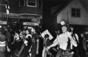
| Date: | 1967 |
|---|---|
| Description: | Father James Groppi (center) and the NAACP participate in a civil rights march. Police are armed and escorting the protestors. The marchers are passing an ... |

| Date: | 1955 |
|---|---|
| Description: | Bottom of the map reads: "PARKING AREA STUDY MILWAUKEE COUNTY ZOOLOGICAL GARDEN SCALE 1"=200" APRIL 21, 1955 TOTAL PARKING AREA - 3736 CARS 31.1 acres". Th... |
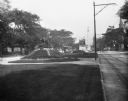
| Date: | 09 1900 |
|---|---|
| Description: | View down Grand Avenue. Near a streetcar is the city's Civil War memorial, erected in 1898 by John Conway. |
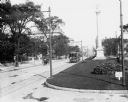
| Date: | 09 1900 |
|---|---|
| Description: | View down Grand Avenue. A streetcar and a horse-drawn wagon are coming up the avenue. There are monuments in the median. |

| Date: | 06 1905 |
|---|---|
| Description: | Stereograph elevated view of the Milwaukee Exposition Building. Handwritten text reads: "1634 Exposition Building." Printed text on postcard is partially c... |

| Date: | 1972 |
|---|---|
| Description: | These maps show the Milwaukee County supervisory districts as of April 1972 and the Supervisor and Assembly districts in effect prior to the April 1972 ele... |

| Date: | 1966 |
|---|---|
| Description: | This map from the 1960s provides a detailed street map of Milwaukee County and eastern Waukesha County as far west as Menomonee Falls and Muskego Lake. A p... |

| Date: | 1968 |
|---|---|
| Description: | A tourist map of Milwaukee County and of downtown Milwaukee. The Map of Milwaukee County identifies the location of some of the points of interests in the ... |

| Date: | 08 14 1968 |
|---|---|
| Description: | A group of children are holding up hand-made signs, demonstrating for "Snoopy for President." Several children are wearing Peanuts t-shirts and sweatshirts... |
| Date: | 1964 |
|---|---|
| Description: | A group of protesters march down a street, led by a car. They are protesting school segregation. |

| Date: | 1911 |
|---|---|
| Description: | Map printed in the Milwaukee Herald, 16th of February, 1912. Includes list of Assembly, State Senate, and Congressional districts in bottom margin. Contain... |

| Date: | 1934 |
|---|---|
| Description: | Map showing the ward boundaries of Milwaukee. Each ward is numbered and boundary streets are labelled. The bottom right corner reads: "CITY ENGINEER'S DEPT... |

| Date: | 1950 |
|---|---|
| Description: | This map is accompanied by booklet: "Know Milwaukee Map and Street Guide". The map is a detailed map of Milwaukee and the surrounding suburbs. Streets and ... |

| Date: | 1940 |
|---|---|
| Description: | This map is pen and ink on paper and is 1 map consisting of 12 sheets. This map includes a numbered key labeling each area, all of which are represented ... |

| Date: | 1927 |
|---|---|
| Description: | Street railway and motor bus map with a legend of "Street Car Line," "Auxiliary Bus Lines," and "Motor Bus Lines." The routes are numbered. The map reads: ... |

| Date: | 1900 |
|---|---|
| Description: | Map shows 6 types of zoning districts in Milwaukee township. There is a key identifying four types of land: "AGRICULTURAL," '"A" RESIDENCE.' '"B" RESIDENCE... |
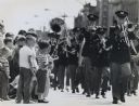
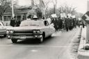
| Date: | 05 31 1962 |
|---|---|
| Description: | View along side of street towards a teenage brass band marching down the street in a Memorial Day parade in West Allis. A group of young children stand on ... |
If you didn't find the material you searched for, our Library Reference Staff can help.
Call our reference desk at 608-264-6535 or email us at: