 Filter: Categories of Wisconsin Historical Images
Filter: Subject of Streets
Filter: Community of Milwaukee
Filter: Subject of water
Filter: Categories of Wisconsin Historical Images
Filter: Subject of Streets
Filter: Community of Milwaukee
Filter: Subject of water
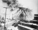
| Date: | 12 11 1926 |
|---|---|
| Description: | Fire destroyed the Atlas Flour Mill, causing an estimated $100,000 in damage. Thirteen engine companies, six truck companies, and two fire boats fought the... |
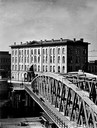
| Date: | |
|---|---|
| Description: | Exterior view of the Axtell House with Walker's Point Bridge in the foreground. |

| Date: | 1853 |
|---|---|
| Description: | Bird's-eye map of Milwaukee looking east toward Lake Michigan from a bluff, long since graded into a slope, at about 6th Street between Wisconsin Avenue an... |
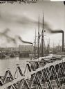
| Date: | |
|---|---|
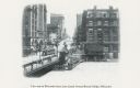
| Description: | Elevated view of Milwaukee River from Walker's Point Bridge. |
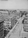
| Date: | |
|---|---|
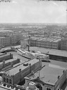
| Description: | Looking east from Mitchell Block. Elevated view of buildings with the lake and a steamship in the distance. |
| Date: | |
|---|---|
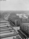
| Description: | Milwaukee, south from Mitchell Block. View shows rooftops and building fronts. Ships and bridge are in the background on the right. |
| Date: | |
|---|---|
| Description: | Elevated view of Milwaukee, looking southwest from Mitchell block showing buildings, and the paddle steamer John A. Dix. |
| Date: | |
|---|---|
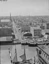
| Description: | Elevated view of Grand Avenue and a bridge over the river, with streetcar and horse-drawn vehicles on the street. |
| Date: | |
|---|---|
| Description: | Elevated view west from Mitchell Block of warehouses, industrial buildings and a church in the background. In the foreground is a waterway with a schooner ... |
| Date: | |
|---|---|
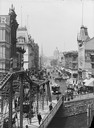
| Description: | View up Wisconsin Avenue towards a bridge with pedestrian and horse-drawn vehicle traffic. Buildings along a street are in the distance. |
| Date: | 07 20 1987 |
|---|---|
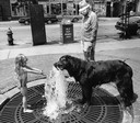
| Description: | A little girl offers her place at a fountain to a large Newfoundland-mix dog who takes a drink on a hot day. |

| Date: | 1898 |
|---|---|
| Description: | Bird's-eye map of Milwaukee with prominent streets and buildings identified. Taken from City Hall Tower. |

| Date: | 1872 |
|---|---|
| Description: | Bird's-eye map of Milwaukee on Lake Michigan. |

| Date: | 1854 |
|---|---|
| Description: | Bird's-eye view of Milwaukee looking east toward Lake Michigan from a bluff, long since graded into a slope, at about 6th Street between Wisconsin Avenue a... |

| Date: | 1937 |
|---|---|
| Description: | Bird's-eye view of Milwaukee in 1853 details building features and city layout from southwest. Important buildings are numbered in a silhouette drawing bel... |
| Date: | 1903 |
|---|---|
| Description: | Elevated view from Wisconsin River looking east. The Pabst Building is on the northwest corner of N. Water Street and E. Wisconsin Avenue with the Mack bui... |

| Date: | 1854 |
|---|---|
| Description: | Bird's-eye illustration of Milwaukee. |

| Date: | 08 23 1913 |
|---|---|
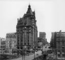
| Description: | Elevated view looking east from W. Wells street across the Milwaukee River. The E. Wells power plant (with arrow), Pabst Theater, and City Hall are on the ... |

| Date: | 1915 |
|---|---|
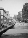
| Description: | View across river toward Wisconsin Street and the River Bridge. Caption reads: "Wisconsin Street, East from River Bridge, Milwaukee, Wis." |
| Date: | 1905 |
|---|---|
| Description: | Slightly elevated view of Wisconsin Street, with the bridge on the left. Caption reads: "View east on Wisconsin Street, from Grand Avenue Buscule Bridge, M... |
If you didn't find the material you searched for, our Library Reference Staff can help.
Call our reference desk at 608-264-6535 or email us at: