 Filter: Categories of Wisconsin Historical Images
Filter: Subject of Streets
Filter: Community of Milwaukee
Filter: Creator Name of Unknown
Filter: Categories of Wisconsin Historical Images
Filter: Subject of Streets
Filter: Community of Milwaukee
Filter: Creator Name of Unknown

| Date: | 1800 |
|---|---|
| Description: | Map of additions to Milwaukee. Several of the additions are outlined in colors and many streets, waterways, and some landmarks are labelled. |

| Date: | 1900 |
|---|---|
| Description: | Map shows 6 types of zoning districts in Milwaukee township. There is a key identifying four types of land: "AGRICULTURAL," '"A" RESIDENCE.' '"B" RESIDENCE... |

| Date: | 1903 |
|---|---|
| Description: | Street surface paved with granite blocks at the intersection of Second and Fowler streets. |

| Date: | 1896 |
|---|---|
| Description: | Snapshot of a young man with two young women chatting on Wisconsin Street. The scene is near the Grand Avenue bridge which appears in the background. |

| Date: | 1905 |
|---|---|
| Description: | Wells Street, between 16th and 18th Streets. Record photograph for a survey of Milwaukee street conditions, made to show the wooden cedar block pavement. T... |

| Date: | 1906 |
|---|---|
| Description: | This map shows ward boundaries, subdivisions, lot and block numbers and dimensions, house numbers, electric car lines, steam railways, and adjoining plat n... |

| Date: | 1892 |
|---|---|
| Description: | This map shows water pipes, hydrants, stop cocks, check valves, fire cysterns, and manholes. Also shown are block numbers, streets, railroads, parks, cemet... |

| Date: | 1893 |
|---|---|
| Description: | This map covers west to Wauwatosa, north to North Milwaukee, and south to South Milwaukee and shows street railways, city limits, parks, roads, railroads, ... |

| Date: | 1899 |
|---|---|
| Description: | This map shows parks, block numbers, Lake Michigan, and railroads. Relief is shown by contours. Also included is an explanation that lists how many miles o... |

| Date: | 1910 |
|---|---|
| Description: | This ink on paper blue line print base map consists of eight separate pieces and shows city limits, The Milwaukee Electric Railroad & Light Company lines, ... |

| Date: | 1924 |
|---|---|
| Description: | This map shows streets, selected buildings, railroads, railway yards, schools, parks, schools, cemeteries, bays, the Milwaukee River, and Lake Michigan. De... |

| Date: | 1948 |
|---|---|
| Description: | This map is ink on tracing paper and shows acreages, wards, streets, rivers, and Lake Michigan. Also included are editorial notes in pencil. |

| Date: | 1890 |
|---|---|
| Description: | Five teenagers ride "High Wheeler or Penny-Farthing" bicycles down the street. Grand Avenue Congregational Church is in the background. Mature trees are on... |

| Date: | 1894 |
|---|---|
| Description: | This map shows sewers, intercepting sewers, manholes, block numbers, streets, railroads, parks, cemeteries, and Lake Michigan. The right margin reads: "Tot... |

| Date: | 1879 |
|---|---|
| Description: | This map shows asylums, cemeteries, hospitals, parks, streets, and wards. Relief is shown by contours. Also included are manuscript annotations in pencil. ... |
| Date: | 1888 |
|---|---|
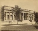
| Description: | View across street towards the facade of the original Layton Art Gallery building at 758 N. Jefferson Street. Two men stand at the top of the stairs betwee... |
| Date: | |
|---|---|
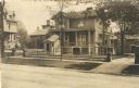
| Description: | A view across street towards Frederick and Elizabeth Layton's home at 534 Marshall Street. The clapboard house has two porches. On the left is a roofed enc... |

| Date: | 04 14 1967 |
|---|---|
| Description: | Bernice Lindsay is standing under a new reflected street name sign in her honor. She is wearing a coat, a hat, and a broach. Beside her is a fire hydrant. ... |

| Date: | 04 14 1967 |
|---|---|
| Description: | Vel Phillips is in a dress on a podium. She is next to Bernice Lindsay, who is wearing a coat and a hat. Behind them is Reverend Lovell Johnson, who is wea... |

| Date: | 04 14 1967 |
|---|---|
| Description: | Alderman Martin E. Schreiber, President of the Milwaukee Common Council, is on a podium wearing a suit. On the left is Vel Phillips who is wearing a dress.... |
If you didn't find the material you searched for, our Library Reference Staff can help.
Call our reference desk at 608-264-6535 or email us at: