 Filter: Categories of Wisconsin Historical Images
Filter: Subject of Streets
Filter: Community of Madison
Filter: Creator Name of Newhouse, John
Filter: Categories of Wisconsin Historical Images
Filter: Subject of Streets
Filter: Community of Madison
Filter: Creator Name of Newhouse, John

| Date: | 1956 |
|---|---|
| Description: | Aerial view of the South Park Street interchange. |
| Date: | 1954 |
|---|---|
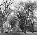
| Description: | State Street from the University of Wisconsin-Madison campus. |
| Date: | 1954 |
|---|---|
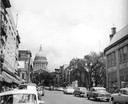
| Description: | A view down State Street looking towards the Wisconsin State Capitol. |

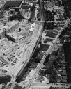
| Date: | 1958 |
|---|---|
| Description: | Aerial view of the Wisconsin State Capitol and surrounding area. The view is looking northwest, with King Street on the bottom right, and S. Hamilton Stree... |

| Date: | 1956 |
|---|---|
| Description: | Aerial view of the Chicago, Milwaukee, and St. Paul Railroad station, roundhouse, and yard at the intersection of West Washington Avenue (across lower left... |
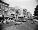
| Date: | 1955 |
|---|---|
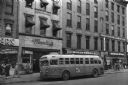
| Description: | Bus traveling down Mifflin Street on Capitol Square. Moseleys, Woldenbergs and Walgreen's Drugs are on the right. |
| Date: | 1956 |
|---|---|
| Description: | View across intersection of the Chicago and Northwestern railroad station at Blair and Wilson Streets. Three tall chimneys from the MG&E plant can be seen ... |
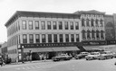
| Date: | 1954 |
|---|---|
| Description: | S.S. Kresge storefront and Miller's clothing store on Main Street. |
| Date: | 1952 |
|---|---|
| Description: | Slightly elevated view of a parade on the Capitol Square, celebrating a visit by Adlai Stevenson, Democratic candidate for President. |
| Date: | 1954 |
|---|---|
| Description: | An air view of Madison including the Veterans Hospital, Forest Products Laboratory and University Avenue from Farley (lower edge), to Allen Streets. |

| Date: | 1956 |
|---|---|
| Description: | Aerial view, looking eastward from a point several miles outside the southwestern limits of Madison in the direction of Verona. Crossing the image diagonal... |

| Date: | 1953 |
|---|---|
| Description: | Aerial view looking southeast over Madison's near east side. The Eagles Club at 1236 Jenifer Street / 1221 Williamson Street is under construction in the ... |

| Date: | 1955 |
|---|---|
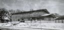
| Description: | Exterior view of Central High School with cars parked in front. |
| Date: | 1954 |
|---|---|
| Description: | A view of Fairchild Street from Mifflin Street. There is a sign on the side of the building on the right that reads: "Casey O'Brien." |
| Date: | 1955 |
|---|---|
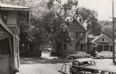
| Description: | View of two houses (108 N. Blount and 102 N. Blount) on North Blount Street taken from Market Place showing a corner of the City Market on the left. |
| Date: | 1954 |
|---|---|
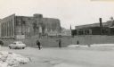
| Description: | The intersection of Mifflin Street and Wisconsin Avenue after the old City Hall (1858-1954) and Fuller Opera House had been torn down. |
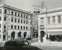
| Date: | 1954 |
|---|---|
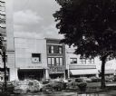
| Description: | Pinckney Street, near the corner of East Washington Avenue. To the left is a bank building, in the center a shoe store, and on the right a theatre. |
| Date: | 1956 |
|---|---|
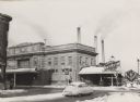
| Description: | A wintery view of the rectory of the Queen of Peace church lacated at 418 Holly Avenue. |
If you didn't find the material you searched for, our Library Reference Staff can help.
Call our reference desk at 608-264-6535 or email us at:

