 Filter: Categories of Wisconsin Historical Images
Filter: Subject of Streetcars
Filter: Subject of streets
Filter: Categories of Wisconsin Historical Images
Filter: Subject of Streetcars
Filter: Subject of streets
| Date: | |
|---|---|
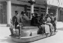
| Description: | View of an open electric tram car with driver and passengers. |

| Date: | 03 30 1912 |
|---|---|
| Description: | An early IH automobile is parked in a street. The automobile features lamps, possibly gas lamps, as well as the IHC logo on the grill. In the background ar... |

| Date: | 1908 |
|---|---|
| Description: | Panoramic view of Madison taken from Summit Avenue looking East South East toward Lake Monona. Included in the view are the Camp Randall bleachers, St. Rap... |

| Date: | 1869 |
|---|---|
| Description: | This map was engraved from original drawings and surveys taken by Louis Lipman. Includes Milwaukee street directory on the left hand side. Bottom right cor... |

| Date: | 1927 |
|---|---|
| Description: | Street railway and motor bus map with a legend of "Street Car Line," "Auxiliary Bus Lines," and "Motor Bus Lines." The routes are numbered. The map reads: ... |
| Date: | 1918 |
|---|---|
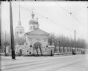
| Description: | View across square of the Church of Rojdestva Kristova (Nativity of Christ) near Archangel [Arkhangelsk], Russia. |
| Date: | 1918 |
|---|---|
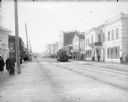
| Description: | The main thoroughfare of Archangel, Russia, called the Troitski Prospect. It shows the electric street car traveling through the town as well as crowds of ... |
| Date: | 1918 |
|---|---|
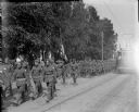
| Description: | DESCRIPTION QUESTION: A group of American soldiers are marching down a street in Archangel [Archangelsk], Russia. Next to the flag barrier is a African Ame... |

| Date: | 1938 |
|---|---|
| Description: | Color coded map in pink, yellow, blue, and brown of Milwaukee County State and County trunk highways. The map includes a legend of symbols: "STEAM RAIL ROA... |

| Date: | 1918 |
|---|---|
| Description: | Elevated view of the Troitsky prospect in Archangel [Archangelsk], Russia, looking north. There are dwellings, commercial and industrial buildings, and a c... |

| Date: | 1918 |
|---|---|
| Description: | Elevated view of Troitsky prospect in Archangel [Archangelsk], Russia, looking south, showing homes, churches, state buildings, and a statue of Peter the G... |

| Date: | 1918 |
|---|---|
| Description: | Elevated view of Troitsky prospect in Archangel [Archangelsk], Russia, looking south, showing homes, churches, state buildings, as well as the statue of Pe... |

| Date: | 1918 |
|---|---|
| Description: | This map shows railroads, street car lines, wards, private claims, parks, railroad yards and depots, and cemeteries. The map is oriented with north to uppe... |

| Date: | 1911 |
|---|---|
| Description: | Composite photograph of a trolley traversing Hillsboro's Main Street. Hillsboro did not actually have a streetcar; the image of the trolley was taken from ... |
| Date: | |
|---|---|
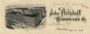
| Description: | Letterhead of the John Pritzlaff Hardware Company, with an elevated three-quarter view of the company building. |
| Date: | 1910 |
|---|---|
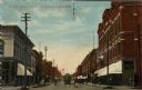
| Description: | Colorized view of Bridge Street, looking north from Spring Street intersection, in the central business district. The view includes stores, some with canva... |

| Date: | 1918 |
|---|---|
| Description: | View from sidewalk on the Capitol Square of band in a parade moving down Mifflin Street near the corner of Wisconsin Avenue. There is a sign for Collyer Ph... |

| Date: | 1901 |
|---|---|
| Description: | This map shows public schools, engine houses, railroads, street railways, city wards, parks, block numbers, and Lake Michigan. Also included are indexes, t... |

| Date: | 1904 |
|---|---|
| Description: | This map has three inset maps of Whitefish Bay, Cudahy, and South Milwaukee. This map depicts schools, engine houses, railroads, street railways, city ward... |

| Date: | 1904 |
|---|---|
| Description: | This map shows wards, schools, engine houses, railroads, street railways, block numbers, parks, roads, and Lake Michigan. Also included are indexes: Table ... |
If you didn't find the material you searched for, our Library Reference Staff can help.
Call our reference desk at 608-264-6535 or email us at: