 Filter: Categories of Wisconsin Historical Images
Filter: Subject of Street-railroads
Filter: Year of 1900-1999
Filter: Categories of Wisconsin Historical Images
Filter: Subject of Street-railroads
Filter: Year of 1900-1999
| Date: | 09 17 1926 |
|---|---|
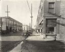
| Description: | Downtown street scene near Commercial and Canal Streets. This image was used in a Circuit Court case. |
| Date: | 09 17 1926 |
|---|---|
| Description: | Downtown street scene and alley near Commercial and Canal Streets. This image was used in a Circuit Court case. |
| Date: | 09 01 1928 |
|---|---|
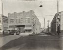
| Description: | Exterior view of an International Harvester Company branch building as seen from across an intersection. Several automobiles are parked in front of the bui... |
| Date: | 1918 |
|---|---|
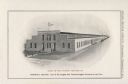
| Description: | Illustration of the Stinson Tractor Company, located at the intersection of Central Avenue and 16th Street. The illustration was included in a booklet prod... |
| Date: | 1920 |
|---|---|
| Description: | Back cover of a brochure advertising Moline Universal tractors. The text beneath an illustration of the Moline Plow Company factory reads: "The Largest Tra... |
| Date: | 08 1925 |
|---|---|
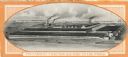
| Description: | The Metro-Goldwyn-Mayer "Trackless Train" parked at the Pennsylvania Oil Company filling station on the corner of State Street and Gorman Street. The "Trac... |
| Date: | 08 1945 |
|---|---|
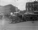
| Description: | The Metro-Goldwyn-Mayer "Trackless Train" turning onto North Carroll Street from West Mifflin Street. The "Trackless Train" was on a tour from New York to ... |
| Date: | 08 1925 |
|---|---|
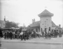
| Description: | The Metro-Goldwyn-Mayer "Trackless Train" parked in front of the Hotel Loraine on West Washington Avenue. The YMCA can be seen on the right. The "Trackless... |
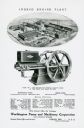
| Date: | 1918 |
|---|---|
| Description: | Back cover of a pamphlet advertising the Worthington Pump and Machinery Corporation. The advertisement features an illustration of the Ingeco Engine Plant ... |

| Date: | 1922 |
|---|---|
| Description: | A road map of Milwaukee County, Wisconsin that shows the township and range system, towns, communities, completed roads, a proposed system of roads, steam ... |

| Date: | 1903 |
|---|---|
| Description: | This 1903 map of Outagamie County, Wisconsin, shows the township and range grid, towns, sections, cities and villages, landownership and acreages, rural ma... |

| Date: | 1911 |
|---|---|
| Description: | Shows roads, railroads, street railways, abandoned logging railroads, rural mail routes, platted land, state forest reserves, and parts of Burnett County, ... |

| Date: | 1931 |
|---|---|
| Description: | This map is an advertisement for Milwaukee street cars and motor buses and reads: "Ride the street car or motor bus. Economical, safe, dependable." Include... |

| Date: | 1917 |
|---|---|
| Description: | Shows property already platted (orange), public property (green), street railway (red lines), Lake Forest development area (red), and some landownership. T... |
| Date: | 1918 |
|---|---|
| Description: | Tramway and railroad leading into Solombola, Russia. In the foreground are a group of people, some sawing wood and others standing by the railroad. |
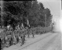
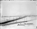
| Date: | 1918 |
|---|---|
| Description: | DESCRIPTION QUESTION: A group of American soldiers are marching down a street in Archangel [Archangelsk], Russia. Next to the flag barrier is a African Ame... |

| Date: | 1960 |
|---|---|
| Description: | Color coded map in pink, yellow, blue, and brown of Milwaukee County State and County trunk highways. The map includes a legend of symbols: "STEAM RAIL ROA... |

| Date: | 1938 |
|---|---|
| Description: | Color coded map in pink, yellow, blue, and brown of Milwaukee County State and County trunk highways. The map includes a legend of symbols: "STEAM RAIL ROA... |
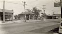
| Date: | 1930 |
|---|---|
| Description: | Businesses located near the intersection of Park and Lakeside Streets, before Park Street was widened. Identified from left, Madison Do-Nut Kitchen, Valvol... |

| Date: | 1909 |
|---|---|
| Description: | This map of Duluth and Superior was issued by the Duluth Street Railway Company and shows street railway routes in the cities, as well as lakes, bays, harb... |
If you didn't find the material you searched for, our Library Reference Staff can help.
Call our reference desk at 608-264-6535 or email us at: