 Filter: Categories of Wisconsin Historical Images
Filter: Subject of Streams
Filter: Subject of water
Filter: Categories of Wisconsin Historical Images
Filter: Subject of Streams
Filter: Subject of water
| Date: | |
|---|---|
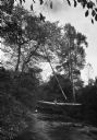
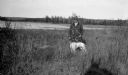
| Description: | View of a boy sitting on a log suspended above a small wooded stream. A man is crouching near the the shore below. |
| Date: | |
|---|---|
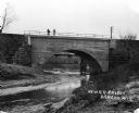
| Description: | View from shoreline of two men standing on a newly constructed railroad bridge over a stream. |
| Date: | 11 31 1910 |
|---|---|
| Description: | Colorized postcard view of The Spring in Decatur Park. A man is sitting near the spring. There is a bridge on the right, and many trees. Text in red in the... |
| Date: | |
|---|---|
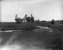
| Description: | The Richardson Farm stands at the far edge of a farm field with a creek running through it and animals grazing. The farmhouse is white and surrounded by tr... |

| Date: | |
|---|---|
| Description: | View of the Eagles Nest, a Japanese Garden featuring a bridge and building amongst plants and trees. |
| Date: | 1910 |
|---|---|
| Description: | The mill race as it flows from Lake Mendota into Tenney Park. |

| Date: | |
|---|---|
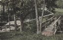
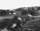
| Description: | View of a bridge over a stream. In the foreground is a tree. Residential homes are in the distance. |
| Date: | |
|---|---|
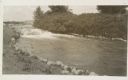
| Description: | Elevated view of a stream with a dam and a bridge. There is a small fenced garden along the water. In the distance is a hillside with houses. |
| Date: | 1937 |
|---|---|
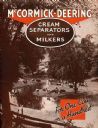
| Description: | Cover of an advertising brochure for the McCormick-Deering cream separators and milking machines (milkers). Includes the text: "For One Cow or a Hundred" a... |
| Date: | 1935 |
|---|---|
| Description: | View down hill of a group of cows resting by a stream near trees and a fence. A handwritten caption reads: "Hamilton, Ontario. Dairy Cows near city. Taken ... |
| Date: | 05 30 1967 |
|---|---|
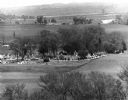
| Description: | View of a parade traveling through a cemetery. Beyond, barns and farmhouses can be seen. |

| Date: | 1918 |
|---|---|
| Description: | Map of Wisconsin along with the western portion of Michigan’s Upper Peninsula, showing county lines, cities and villages, lakes, streams, and railroads. Po... |

| Date: | 1863 |
|---|---|
| Description: | This map is a hand-colored, pen and ink, drawing by Ole R. Dahl of Co. B, 15 Wisconsin Infantry shows the battlefield at Stones River, depicting roads, str... |

| Date: | 1865 |
|---|---|
| Description: | This map is a pen and ink tracing. Union positions are shown in blue and Confederate positions are shown in red. Roads, vegetation, and streams are labeled... |

| Date: | |
|---|---|
| Description: | Letterhead of Madison Mobile Homes, with a three-quarter view of a mobile home parked in a clearing near a wooded area on a shoreline, with the slogan "Liv... |

| Date: | 1917 |
|---|---|
| Description: | A geological survey map of southeastern Wisconsin that shows the configuration of the bedrock beneath the glacial drift and other deposits in southeastern ... |

| Date: | 1917 |
|---|---|
| Description: | A geological survey map that map of southeastern Wisconsin shows the surface deposits east of the Wisconsin River, from the Illinois state line north to Ne... |
| Date: | 1923 |
|---|---|
| Description: | A well-dressed man poses holding a German short-haired pointer on a leash near the outlet of the Fish Creek into the harbor. |
If you didn't find the material you searched for, our Library Reference Staff can help.
Call our reference desk at 608-264-6535 or email us at:

