 Filter: Categories of Wisconsin Historical Images
Filter: Subject of Streams
Filter: Subject of transportation
Filter: Categories of Wisconsin Historical Images
Filter: Subject of Streams
Filter: Subject of transportation

| Date: | |
|---|---|
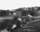
| Description: | View of a bridge over a stream. In the foreground is a tree. Residential homes are in the distance. |
| Date: | |
|---|---|
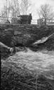
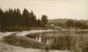
| Description: | Elevated view of a stream with a dam and a bridge. There is a small fenced garden along the water. In the distance is a hillside with houses. |

| Date: | 1918 |
|---|---|
| Description: | Map of Wisconsin along with the western portion of Michigan’s Upper Peninsula, showing county lines, cities and villages, lakes, streams, and railroads. Po... |

| Date: | 1863 |
|---|---|
| Description: | This map is a hand-colored, pen and ink, drawing by Ole R. Dahl of Co. B, 15 Wisconsin Infantry shows the battlefield at Stones River, depicting roads, str... |

| Date: | 1865 |
|---|---|
| Description: | This map is a pen and ink tracing. Union positions are shown in blue and Confederate positions are shown in red. Roads, vegetation, and streams are labeled... |

| Date: | 1917 |
|---|---|
| Description: | A geological survey map of southeastern Wisconsin that shows the configuration of the bedrock beneath the glacial drift and other deposits in southeastern ... |

| Date: | 1917 |
|---|---|
| Description: | A geological survey map that map of southeastern Wisconsin shows the surface deposits east of the Wisconsin River, from the Illinois state line north to Ne... |
| Date: | 04 1922 |
|---|---|
| Description: | The photographer's wife Clothilde leans on a railing, looking at water rushing through a stone culvert on Fish Creek. Their car is parked on the roadway. A... |

| Date: | 1912 |
|---|---|
| Description: | This map shows the area around Fort McCoy, labeled "U.S. Military Reservation," and Camp Douglas in the Sparta-Tomah region. Road, railroads, towns, cities... |
| Date: | 1920 |
|---|---|
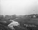
| Description: | View from low hill of a stream flowing through fields. There are cows in the pasture on the right. In the distance is a bridge, road, and buildings. |
| Date: | 1915 |
|---|---|
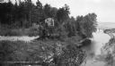
| Description: | Elevated view of a two-story house sited beside Shivering Sands Creek where it enters Lake Michigan. There is a rustic footbridge over the stream close to ... |

| Date: | |
|---|---|
| Description: | A map of Grant County, Wisconsin that shows the townships, cities, villages, rivers and streams, roads and railroads, landownership, post offices. The map... |

| Date: | 1926 |
|---|---|
| Description: | A topographic map of Green County, showing by contours and spot heights the topographic and natural features of the county. The contour intervals are 20 fe... |
| Date: | 1920 |
|---|---|
| Description: | View along shoreline towards a rustic foot bridge which crosses the mouth of Fish Creek, which separates the village of Fish Creek from Peninsula State Par... |

| Date: | 1896 |
|---|---|
| Description: | A map of Green Lake County, Wisconsin, shows township divisions, villages and post offices, railroads, roads, lakes and streams, schools, and churches. |

| Date: | 1906 |
|---|---|
| Description: | A map of Berlin, Wisconsin and the surrounding area, showing the old channel of the Fox River and the site of Mascouten village just south of that city in ... |

| Date: | 1901 |
|---|---|
| Description: | A hand-colored map of Iowa County, Wisconsin, shows townships and sections, towns, cities and villages, streams, landownership, roads, railroads and rural ... |

| Date: | 1932 |
|---|---|
| Description: | A map of Iron County, Wisconsin, shows towns and sections, lakes and streams, villages, railroads, roads, and La Point and Lac Du Flambeau Indian reservati... |

| Date: | |
|---|---|
| Description: | A map that shows the Wisconsin Central Railway land grant lands for sale by the Soo Line, the Chicago, Milwaukee, and St. Paul Railway. Town sections, lak... |

| Date: | |
|---|---|
| Description: | Map of northern Iron County, Wisconsin, shows town sections and railroads in the towns of Saxon, Kimball, and Gurney. It also includes the area of the La P... |
If you didn't find the material you searched for, our Library Reference Staff can help.
Call our reference desk at 608-264-6535 or email us at: