 Filter: Categories of Wisconsin Historical Images
Filter: Subject of Streams
Filter: Subject of streets
Filter: Categories of Wisconsin Historical Images
Filter: Subject of Streams
Filter: Subject of streets

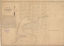
| Date: | 1861 |
|---|---|
| Description: | This 1861 map of Columbia County, Wisconsin, shows the township and range grid, towns, sections, cities and villages, railroads, roads, property owners and... |

| Date: | 1860 |
|---|---|
| Description: | This map of Dodge County, Wisconsin, shows the township and range grid, towns, sections, cities and villages, railroads, roads, property owners and acreage... |

| Date: | 1987 |
|---|---|
| Description: | This 1987 map of Door County, Wisconsin, shows streets and roads, cities and villages, state parks, lakes and streams, and depths in Lake Michigan. A stree... |
| Date: | 1849 |
|---|---|
| Description: | The map reads: "Dartford is centrally located in Wisconsin, on the north side of Green Lake, and in full view of that beautiful sheet of Water. Its precise... |
| Date: | 1930 |
|---|---|
| Description: | Map reads: "Plat showing Location of Creamery on apart of The NorthEast 1/4 of the NorthWest 1/4 of Sec 31, T. 30 N.R. 14 W. The map notes creamery buildin... |
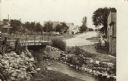
| Date: | 1908 |
|---|---|
| Description: | View of a street going through the center of town. In the foreground is a stream and a bridge. Commercial buildings and dwellings are on the left. |

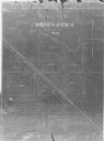
| Date: | 1938 |
|---|---|
| Description: | This map shows plat of town, boundary lines of assessors blocks, land ownership by name, local streets, railroads, wards, lots, and parts of Cedar Creek. T... |

| Date: | 1960 |
|---|---|
| Description: | This map shows lot numbers and dimensions, railroad, and streets. Fall Creek and Mill Pond (now Fall Creek Pond) are labeled. The map is a blue line print. |

| Date: | 1923 |
|---|---|
| Description: | Map showing the parcel of land on the shore of Lake Monona acquired by the City of Madison for a park (today known as Olbrich Park). |

| Date: | 1911 |
|---|---|
| Description: | This map shows plat of town, local streets, numbered lots, blocks, and wards, roads, Lake Menomin, Wilson Creek, Red Cedar River, and land ownership by nam... |

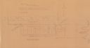
| Date: | 12 1903 |
|---|---|
| Description: | This manuscript blueprint map shows streets and lots and includes certifications in the left margin. Horizontal streets top to bottom are: Iroquois, Main, ... |
| Date: | 1900 |
|---|---|
| Description: | This map shows the blocks and streets that make up the village, and includes the Baraboo Air Line Railroad which cuts through the village at a diagonal fro... |

| Date: | 1907 |
|---|---|
| Description: | Photographic collage of ten views of Delavan, including churches, lakes, and street scenes. Caption reads: "Views of Delavan, Wis." |
If you didn't find the material you searched for, our Library Reference Staff can help.
Call our reference desk at 608-264-6535 or email us at: