Filter: Categories of Wisconsin Historical Images
Filter: Subject of Streams
Filter: Subject of rivers
Filter: Categories of Wisconsin Historical Images
Filter: Subject of Streams
Filter: Subject of rivers

| Date: | 1936 |
|---|---|
| Description: | This map is red and black ink on tracing cloth and is oriented with north to the upper left. This hand-drawn map shows a central portion of the military ro... |

| Date: | 1874 |
|---|---|
| Description: | This map shows lakes, rivers, state, county, and town boundaries, as well as railroads completed, in progress, and contemplated. The map includes a color d... |
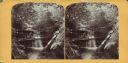
| Date: | |
|---|---|
| Description: | View from hill over a valley dotted with farmsteads and a meandering stream in the foreground. A group of three or four people are posing at the opposite s... |
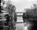
| Date: | 1909 |
|---|---|
| Description: | View from river of Dell Creek bridge with bluff and birch trees on the left. |
| Date: | 1905 |
|---|---|
| Description: | Henry A. Dahl, member of the Menomonie High School class of 1905, depicted as a fisherman. Pictured with a long wooden pole and a straw hat. Part of a year... |
| Date: | |
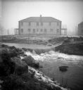
|---|---|
| Description: | The Root River swollen with rainwater and/or snow melt. A recently built duplex housing unit is visible in the background. This picture was likely taken as... |
| Date: | |
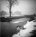
|---|---|
| Description: | The Root River, swollen with rainwater and/or snow melt, runs under a bridge on which a man is walking. Recently built houses are visible in the misty back... |
| Date: | |
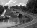
|---|---|
| Description: | Five combined locks between the Hudson River and Lake Champlain in a wooded area. A dirt road runs along one side and a stepped concrete stream-bed runs a... |
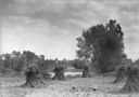
| Date: | 1925 |
|---|---|
| Description: | Corn shocks stand in a field with several pumpkins on the ground. There is a stream or river along the field, and in the background is a bridge over a dam... |

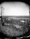
| Date: | |
|---|---|
| Description: | Exterior photograph of the first water works in America, consisting of a stone cottage next to a stream. |

| Date: | 1864 |
|---|---|
| Description: | View down to valley of Union soldiers posing on the roof of a log building. A log bridge crosses a stream, and many trees are on the hillsides. Plate 05... |

| Date: | 10 1884 |
|---|---|
| Description: | Sanborn insurance map of Black River Falls covering the area bordered by the Black River on the East, 3rd Street on the West, Johnson Street on the North, ... |
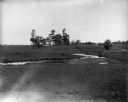
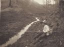
| Date: | |
|---|---|
| Description: | The Richardson Farm stands at the far edge of a farm field with a creek running through it and animals grazing. The farmhouse is white and surrounded by tr... |

| Date: | |
|---|---|
| Description: | View of a bridge over a stream. In the foreground is a tree. Residential homes are in the distance. |

| Date: | 1918 |
|---|---|
| Description: | Map of Wisconsin along with the western portion of Michigan’s Upper Peninsula, showing county lines, cities and villages, lakes, streams, and railroads. Po... |

| Date: | 1917 |
|---|---|
| Description: | A geological survey map of southeastern Wisconsin that shows the configuration of the bedrock beneath the glacial drift and other deposits in southeastern ... |

| Date: | 1917 |
|---|---|
| Description: | A geological survey map that map of southeastern Wisconsin shows the surface deposits east of the Wisconsin River, from the Illinois state line north to Ne... |
If you didn't find the material you searched for, our Library Reference Staff can help.
Call our reference desk at 608-264-6535 or email us at: