Filter: Categories of Wisconsin Historical Images
Filter: Subject of Streams
Filter: Subject of military art and science
Filter: Categories of Wisconsin Historical Images
Filter: Subject of Streams
Filter: Subject of military art and science

| Date: | 1936 |
|---|---|
| Description: | This map is red and black ink on tracing cloth and is oriented with north to the upper left. This hand-drawn map shows a central portion of the military ro... |
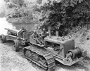
| Date: | 05 15 1941 |
|---|---|
| Description: | Three African American field artillery soldiers crossing a creek on a TD-18 diesel crawler tractor (TracTracTor) and 155 mm gun. The soldiers were from Bat... |

| Date: | 08 10 1862 |
|---|---|
| Description: | A hand-drawn map of the Battle of Wilson's Creek, Springfield, Missouri. Other notes and locations include: "Lyon was killed instantly while heading his tr... |

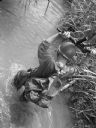
| Date: | 1942 |
|---|---|
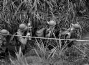
| Description: | Rear view of soldiers holding their rifles above their heads as they ford a stream in Panama. |
| Date: | |
|---|---|
| Description: | View from above of a soldier fording a stream with grassy banks near Fort Davis, Panama, holding his rifle over his head. He is wearing fatigues and a bac... |
| Date: | |
|---|---|
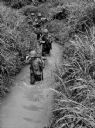
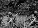
| Description: | Soldiers ford a stream in Panama holding their rifles. |
| Date: | |
|---|---|
| Description: | Elevated view of soldiers fording a stream in Panama. |
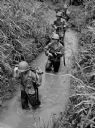
| Date: | |
|---|---|
| Description: | Soldiers fording a stream in Panama holding rifles high. |

| Date: | 1864 |
|---|---|
| Description: | View down to valley of Union soldiers posing on the roof of a log building. A log bridge crosses a stream, and many trees are on the hillsides. Plate 05... |

| Date: | 1863 |
|---|---|
| Description: | This map is a hand-colored, pen and ink, drawing by Ole R. Dahl of Co. B, 15 Wisconsin Infantry shows the battlefield at Stones River, depicting roads, str... |

| Date: | 1865 |
|---|---|
| Description: | This map is a pen and ink tracing. Union positions are shown in blue and Confederate positions are shown in red. Roads, vegetation, and streams are labeled... |

| Date: | 1912 |
|---|---|
| Description: | This map shows the area around Fort McCoy, labeled "U.S. Military Reservation," and Camp Douglas in the Sparta-Tomah region. Road, railroads, towns, cities... |

| Date: | 1931 |
|---|---|
| Description: | A topographical map from the U.S. Army Corp of Engineers showing the topography and man-made features in the Camp Williams area of the towns of Orange and ... |

| Date: | 1940 |
|---|---|
| Description: | This maps shows the areas in Monroe, Jackson, and Juneau counties, Wisconsin, where U.S. Army maneuvers were held in August 1940. Highways and roads, commu... |

| Date: | 1915 |
|---|---|
| Description: | This 1915 map covers portions of Barron, Chippewa, and Rusk counties in Wisconsin. Shown are the township and range grid, sections, cities and villages, ra... |

| Date: | 1867 |
|---|---|
| Description: | This 1867 manuscript map by Increase Lapham shows the topography and geology of the Blue Mounds region in the Town of Brigham in Iowa County and the towns ... |
| Date: | 10 24 1943 |
|---|---|
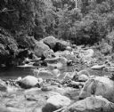
| Description: | Robert Doyle's caption says it best, "The ol' swimmin' hole, South Pacific style. Every afternoon it is filled with shouting soldiers in their birthday sui... |
| Date: | 10 24 1943 |
|---|---|
| Description: | Robert Doyle's caption for Image ID: 99742 says it best, "The ol' swimmin' hole, South Pacific style. Every afternoon it is filled with shouting soldiers i... |
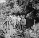
| Date: | 10 24 1943 |
|---|---|
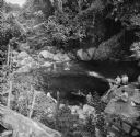
| Description: | Three officers of General Walter Krueger's staff stand on a log in front of a swimming hole located on Goodenough Island, in the Solomon Sea, New Guinea (p... |
If you didn't find the material you searched for, our Library Reference Staff can help.
Call our reference desk at 608-264-6535 or email us at: