 Filter: Categories of Wisconsin Historical Images
Filter: Subject of Streams
Filter: Subject of human settlements
Filter: Year of 1900-1999
Filter: Categories of Wisconsin Historical Images
Filter: Subject of Streams
Filter: Subject of human settlements
Filter: Year of 1900-1999

| Date: | 1975 |
|---|---|
| Description: | This standard U.S.G.S. topographic map was annotated by civil engineer and railroad historian James P. Kaysen to show the location of existing and defunct ... |

| Date: | 1960 |
|---|---|
| Description: | This map shows lot numbers and dimensions, railroad, and streets. Fall Creek and Mill Pond (now Fall Creek Pond) are labeled. The map is a blue line print. |

| Date: | 1923 |
|---|---|
| Description: | Map showing the parcel of land on the shore of Lake Monona acquired by the City of Madison for a park (today known as Olbrich Park). |

| Date: | 1911 |
|---|---|
| Description: | This map shows plat of town, local streets, numbered lots, blocks, and wards, roads, Lake Menomin, Wilson Creek, Red Cedar River, and land ownership by nam... |

| Date: | 1956 |
|---|---|
| Description: | This map shows reservation boundaries, U.S. township lines, highways, roads, rivers, and lakes. The lower left corner of the map includes a legend of "Conv... |

| Date: | 01 1969 |
|---|---|
| Description: | A map of Oneida county, which includes a small drawing of a hodag. |

| Date: | 12 1903 |
|---|---|
| Description: | This manuscript blueprint map shows streets and lots and includes certifications in the left margin. Horizontal streets top to bottom are: Iroquois, Main, ... |
| Date: | 1900 |
|---|---|
| Description: | This map shows the blocks and streets that make up the village, and includes the Baraboo Air Line Railroad which cuts through the village at a diagonal fro... |

| Date: | 1930 |
|---|---|
| Description: | This map shows schools, school districts, town sections, highways, railroads, and hydrography of the area around Hurley. The right margin includes and expl... |

| Date: | 1955 |
|---|---|
| Description: | This map shows roads, golf courses, airports, fire towers, schools, camp grounds, rivers, streams, lakes, and railroads. The right margin of the map includ... |

| Date: | 1905 |
|---|---|
| Description: | Hand-colored view of the Methodist Episcopal Church on Portland Avenue. Cedar Creek flows behind it. Caption reads: "M.E. Church, Cedarburg, Wis." |

| Date: | 1907 |
|---|---|
| Description: | Photographic collage of ten views of Delavan, including churches, lakes, and street scenes. Caption reads: "Views of Delavan, Wis." |
| Date: | 1912 |
|---|---|
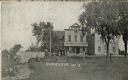
| Description: | View along stream towards people standing in front of buildings and near a stone bridge. The buildings include a post office and a feed mill. Caption reads... |

| Date: | 1950 |
|---|---|
| Description: | View of the rustic bridge in Lakeside Park featuring railings made of branches. Caption reads: "Rustic Bridge, Lakeside Park, Fond du Lac, Wis." |

| Date: | 1910 |
|---|---|
| Description: | View down the railroad tracks, with the depot and grain elevator on the right. A bridge is crossing a stream on the left. Caption reads: "Depot & Elevator,... |

| Date: | 1972 |
|---|---|
| Description: | A topographic map of the Blackwell quadrangle. |
| Date: | 1917 |
|---|---|
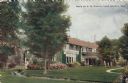
| Description: | View of a private residence, with a stream running through the lawn in the foreground. Caption reads: "Home of S. B. Chapin, Lake Geneva, Wis." |

| Date: | 1912 |
|---|---|
| Description: | View of a stream going through a park. Caption reads: "Picnic Grounds, Silver Creek, Manitowoc, Wis." |

| Date: | 1949 |
|---|---|
| Description: | Black Earth Creek in the winter, with the banks covered with snow. Large trees are leaning over the creek on the right bank. In the background are a fence,... |
If you didn't find the material you searched for, our Library Reference Staff can help.
Call our reference desk at 608-264-6535 or email us at:
