Filter: Categories of Wisconsin Historical Images
Filter: Subject of Streams
Filter: Subject of forests and forestry
Filter: Categories of Wisconsin Historical Images
Filter: Subject of Streams
Filter: Subject of forests and forestry
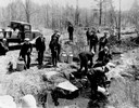
| Date: | 04 26 1936 |
|---|---|
| Description: | Planting trout in Waupaca County. Left to right on bank: S.A. LaVoilette, Joe Samz, Lloyd Pinkawski, Edwin Kargewski, W.M. Geiger, G. Moder, Billy LaVoilet... |
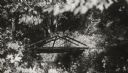
| Date: | |
|---|---|
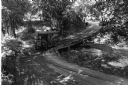
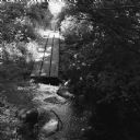
| Description: | Rustic log footbridge over a creek in the woods. |
| Date: | |
|---|---|
| Description: | Elevated view of dredging operations at the mouth of Bear Creek in Canada. Caption reads: "Dredging Operations at the Mouth of Bear Creek, Dawson, Y.T." |
| Date: | |
|---|---|
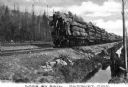
| Description: | Three men are standing on the last railroad car which is carrying logs down a railroad track. Another set of tracks are running parallel on the left, and b... |
| Date: | |
|---|---|
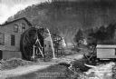
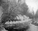
| Description: | View toward a mill with a large water wheel and spring branch, near King Solomon's Cave. A man is posed standing next to the middle of the water wheel. Cap... |

| Date: | |
|---|---|
| Description: | Map of northern Iron County, Wisconsin, shows town sections and railroads in the towns of Saxon, Kimball, and Gurney. It also includes the area of the La P... |

| Date: | 1959 |
|---|---|
| Description: | This map identifies public forest land and industrial forest land as of 1959 in Oneida County, Wisconsin, using a 1930 base map showing the township and ra... |

| Date: | 1935 |
|---|---|
| Description: | This pictorial map of northern Bayfield County, Wisconsin, shows the Chequamegon National Forest, the Red Cliff Indian Reservation, highways and roads, and... |

| Date: | 1940 |
|---|---|
| Description: | This map of Taylor County, Wisconsin, shows the township and range grid, towns, sections, cities and villages, railroads, roads, creameries and cheese fact... |

| Date: | 1960 |
|---|---|
| Description: | This mid-20th century tourist brochure for Bayfield County, Wisconsin, includes a map of the county showing towns, cities and villages, highways and roads,... |

| Date: | 1934 |
|---|---|
| Description: | This 1934 zoning map of Iron County, Wisconsin, shows the township and range grid, towns, sections, roads, and lakes and streams. Forestry and recreation d... |
| Date: | 12 15 1969 |
|---|---|
| Description: | This photograph was likely taken by the International Harvester Overseas Division for promotional purposes, and shows a "Suiza Dairy" International Harvest... |
| Date: | |
|---|---|
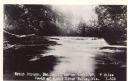
| Description: | Photographic postcard view of a trout stream with rapids and trees on the shoreline. Caption reads: "Trout Steam, Fallhall Glen on Trail 27, 7 Miles South ... |
| Date: | 1958 |
|---|---|
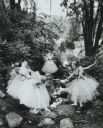
| Description: | Girls of a visiting ballet company, in costume, posed in a rocky wooded glen along a stream. |
| Date: | |
|---|---|
| Description: | View of a creek with ice-covered and tree-lined banks. Identified as Perry Creek. |
| Date: | 08 2013 |
|---|---|
| Description: | View across rocks in a stream towards a board pathway that vanishes into the distance. Oak savanna in late summer. |

| Date: | |
|---|---|
| Description: | View down stream which is flowing down along a steep rock wall on the right. There is a fallen tree trunk resting in the stream. Trees and plants are along... |
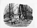
| Date: | 1962 |
|---|---|
| Description: | Imaginative pen-and-ink drawing of a fisherman wearing waders in a creek at the juncture of a cascading stream. He is surrounded by trees and forest berms.... |
If you didn't find the material you searched for, our Library Reference Staff can help.
Call our reference desk at 608-264-6535 or email us at: