 Filter: Categories of Wisconsin Historical Images
Filter: Subject of Streams
Filter: Subject of canals
Filter: Categories of Wisconsin Historical Images
Filter: Subject of Streams
Filter: Subject of canals

| Date: | 1837 |
|---|---|
| Description: | A pen and ink on tracing paper, hand-drawn and colored map the proposed route of the Milwaukee and Rock River Canal, ranging from the Rock River in the wes... |

| Date: | |
|---|---|
| Description: | This 19th century manuscript map of the Town of Oconomoc, Waukesha County, Wisconsin, is drawn on a printed township grid. It shows landownership and lakes... |

| Date: | 1918 |
|---|---|
| Description: | This 1918 map of Chippewa County, Wisconsin, shows the township and range grid, towns, sections, cities and villages, rural residences, churches, schools, ... |
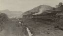
| Date: | 03 1913 |
|---|---|
| Description: | An elevated view of the vast excavation of the Culebra Cut during construction of the Panama Canal. Railroad tracks and a stream are running through the cu... |
If you didn't find the material you searched for, our Library Reference Staff can help.
Call our reference desk at 608-264-6535 or email us at: