 Filter: Categories of Wisconsin Historical Images
Filter: Subject of Streams
Filter: County of Marquette
Filter: Categories of Wisconsin Historical Images
Filter: Subject of Streams
Filter: County of Marquette
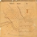
| Date: | |
|---|---|
| Description: | This manuscript map shows the township and range system and lakes and streams in the vicinity of the Fox River, Puckaway Lake, and Buffalo Lake in the town... |
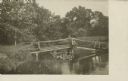
| Date: | 1910 |
|---|---|
| Description: | Water from French Creek covers the surface of a bridge at Dates Mill near the Marquette-Columbia County line. The caption on the negative envelope states: ... |

| Date: | 1910 |
|---|---|
| Description: | Water from French Creek covers the surface of a bridge at Dates Mill near the Marquette-Columbia County line as water rushes down a lane in the pasture in ... |

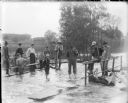
| Date: | 1905 |
|---|---|
| Description: | View upstream towards five young men and boys posing on the flooded bridge at Dates Mill as water rushes from the swollen mill pond into French Creek. Anot... |
| Date: | 09 19 1910 |
|---|---|
| Description: | Text on front reads: "Scene on Buck Creek, Westfield, Wis." A seated man and a standing boy pose on a wooden bridge over Buck Creek. The bridge has railing... |
If you didn't find the material you searched for, our Library Reference Staff can help.
Call our reference desk at 608-264-6535 or email us at: