 Filter: Categories of Wisconsin Historical Images
Filter: Subject of Streams
Filter: County of Dunn
Filter: Categories of Wisconsin Historical Images
Filter: Subject of Streams
Filter: County of Dunn
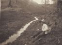
| Date: | 1905 |
|---|---|
| Description: | Henry A. Dahl, member of the Menomonie High School class of 1905, depicted as a fisherman. Pictured with a long wooden pole and a straw hat. Part of a year... |
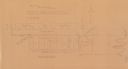
| Date: | 1930 |
|---|---|
| Description: | Map reads: "Plat showing Location of Creamery on apart of The NorthEast 1/4 of the NorthWest 1/4 of Sec 31, T. 30 N.R. 14 W. The map notes creamery buildin... |
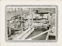
| Date: | 1932 |
|---|---|
| Description: | An open wooden structure built over a small mill race supports a vertical water wheel. A large belt runs horizontally from the water wheel to a line shaft ... |

| Date: | 1911 |
|---|---|
| Description: | This map shows plat of town, local streets, numbered lots, blocks, and wards, roads, Lake Menomin, Wilson Creek, Red Cedar River, and land ownership by nam... |

| Date: | 1932 |
|---|---|
| Description: | View of a footbridge over a stream in the woods. Caption reads: "Rustic Bridge, Menomonie, Wis." |
If you didn't find the material you searched for, our Library Reference Staff can help.
Call our reference desk at 608-264-6535 or email us at: