 Filter: Categories of Wisconsin Historical Images
Filter: Subject of Streams
Filter: Creator Name of Unknown
Filter: Categories of Wisconsin Historical Images
Filter: Subject of Streams
Filter: Creator Name of Unknown

| Date: | 1890 |
|---|---|
| Description: | This late-19th century map of Dane County, Wisconsin, shows the township and range grid, towns, sections, cities and villages, lakes and streams, roads, an... |
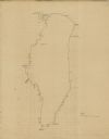
| Date: | |
|---|---|
| Description: | This 19th century manuscript map shows First Lake, Second Lake, streams, and sections in the towns of Dunn and Pleasant Springs, Dane County, Wisconsin. |

| Date: | 1911 |
|---|---|
| Description: | This map, taken from the 1911 Map of Wisconsin showing geology and roads by Hotchkiss and Thwaites, shows the northwest portion of Douglas County, Wisconsi... |

| Date: | 1890 |
|---|---|
| Description: | This map of Douglas County, Wisconsin, published around the beginning of the 20th century shows the copper bearing formations in the county on a map that a... |
| Date: | |
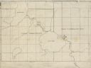
|---|---|
| Description: | This manuscript map of Lake Winnebago shows the streams flowing into the lake and identifies the sections and the cities and villages in the vicinity of th... |

| Date: | 1910 |
|---|---|
| Description: | This early 20th century map of Wood County, Wisconsin, shows the township and range grid, towns, sections, cities and villages, roads and railroads, and st... |

| Date: | 1898 |
|---|---|
| Description: | This 1896 map of the Chain-O-Lakes region of Waupaca County, Wisconsin, shows the lakes and streams, some topography, archaeological sites, roads, railroad... |

| Date: | 1939 |
|---|---|
| Description: | This map of Walworth County, Wisconsin, shows the township and range grid, sections, cities and town, and lakes and streams in the county. It lacks the key... |

| Date: | 1939 |
|---|---|
| Description: | This map of Walworth County, Wisconsin, shows the lakes and streams flowing into the Fox River and the lakes and streams flowing into the Rock River. The d... |

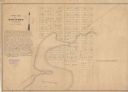
| Date: | 1900 |
|---|---|
| Description: | This 1900 map of Waukesha County, Wisconsin, shows the township and range grid, towns, sections, cities and villages, rural landowners and acreages, railro... |

| Date: | 1939 |
|---|---|
| Description: | This 1939 map of Saint Croix County, Wisconsin, shows the township and range grid, cities and villages, and lakes and streams. |
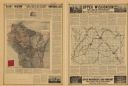
| Date: | 1910 |
|---|---|
| Description: | This map from around 1916 shows the Soo Line railroad lines on a soil map of the state of Wisconsin. The map on the verso shows the township and range grid... |

| Date: | 1928 |
|---|---|
| Description: | Shows different types of roads, railroads, schools, churches, farmsteads, cheese factories, mine shafts, old surface workings, streams, old sulphur pits, a... |
| Date: | 1849 |
|---|---|
| Description: | The map reads: "Dartford is centrally located in Wisconsin, on the north side of Green Lake, and in full view of that beautiful sheet of Water. Its precise... |
| Date: | 1932 |
|---|---|
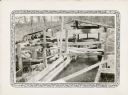
| Description: | An open wooden structure built over a small mill race supports a vertical water wheel. A large belt runs horizontally from the water wheel to a line shaft ... |
| Date: | 1931 |
|---|---|
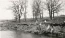
| Description: | View across water towards a group of pupils from the Dyer School fishing from the banks of a stream "about a mile south of school." They are using long can... |
| Date: | 1935 |
|---|---|
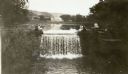
| Description: | Five women pose at the dam built by Frank Lloyd Wright at his home near Spring Green, Wisconsin. A sixth figure is obscured by tree branches on the right. ... |

| Date: | 1850 |
|---|---|
| Description: | A map which includes the ink and pencil annotations showing the sections, sold parcels of land, and streams and lakes on a printed township base map for To... |

| Date: | 1850 |
|---|---|
| Description: | Map is pen and pencil on paper. The map shows roads, creeks, and the Chequamegon Bay. The map is undated and prepared sometime between the establishment of... |
| Date: | |
|---|---|
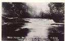
| Description: | Photographic postcard view of a trout stream with rapids and trees on the shoreline. Caption reads: "Trout Steam, Fallhall Glen on Trail 27, 7 Miles South ... |
If you didn't find the material you searched for, our Library Reference Staff can help.
Call our reference desk at 608-264-6535 or email us at: