Filter: Categories of Wisconsin Historical Images
Filter: Subject of State parks and reserves
Filter: Subject of water
Filter: Subject of recreation areas
Filter: Categories of Wisconsin Historical Images
Filter: Subject of State parks and reserves
Filter: Subject of water
Filter: Subject of recreation areas
| Date: | 1902 |
|---|---|
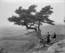
| Description: | Two women and a man pose atop Gibraltar Rock in Richmond Memorial Park, which was dedicated by Jens Jensen and the Wisconsin Friends in 1927 in order to co... |

| Date: | 04 14 1974 |
|---|---|
| Description: | View of the Tenney Park bridge casting a reflection in the water of the lagoon. |

| Date: | 1960 |
|---|---|
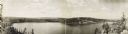
| Description: | View of Ennis Lake, also known as Fountain Lake, located in the John Muir Memorial Park near Montello. As a boy, John Muir lived with his family on the sho... |

| Date: | 1960 |
|---|---|
| Description: | View of Ennis Lake, also known as Fountain Lake, located in the John Muir Memorial Park near Montello. As a boy, John Muir lived with his family on the sho... |
| Date: | |
|---|---|
| Description: | Children and adults gather at Devil's Lake. Shown at the right is a large water slide. |
| Date: | 1934 |
|---|---|
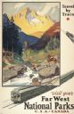
| Description: | An original lithograph promoting the national parks of the western United States and Canada, as well as promoting train travel. The poster depicts a creek... |

| Date: | |
|---|---|
| Description: | View across water toward the Montauk Lighthouse, in Montauk Point State Park, a U.S. Government Reservation on Long Island. Several people are playing on t... |
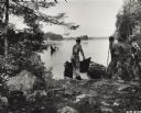
| Date: | 08 15 1948 |
|---|---|
| Description: | Sigurd Olson during the American Forest Trail ride at Brent Lake in Quetico Provincial Park. |
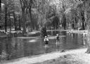
| Date: | 1936 |
|---|---|
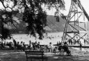
| Description: | A view of the Marathon County Park. Many children are playing in the water surrounding a stone fountain, while others watch from the benches. |
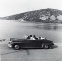
| Date: | 1956 |
|---|---|
| Description: | Lewis, LuRay, Nellie and Bernard Arms arrive at Devil's Lake in a maroon DeSoto convertible automobile. This was the day after Lewis and LuRay's wedding. |

| Date: | |
|---|---|
| Description: | Elevated view of Devil's Lake and surrounding area from a bluff on the east side of the lake. A man is standing on top of the rock formation near the cente... |

| Date: | 1939 |
|---|---|
| Description: | This nine-part map from the U.S. Bureau of Public Roads identifies federal and state highways in Wisconsin by pavement type. County, forest, park, and publ... |

| Date: | 1944 |
|---|---|
| Description: | This nine-part map from the U.S. Bureau of Public Roads identifies federal and state highways in Wisconsin by pavement type. County, forest, park, and publ... |

| Date: | 1920 |
|---|---|
| Description: | View from shoreline of a water slide at Mirror Lake State Park. A woman rides down the slide into the lake, and a few people stand on the platform behind h... |

| Date: | 1990 |
|---|---|
| Description: | This late 20th century tourist map of Sauk County, Wisconsin, shows the highways and roads, cities and towns, parks, airports, canoe landings, hospitals, s... |

| Date: | 02 1956 |
|---|---|
| Description: | This 1956 map of Waukesha County, Wisconsin, shows the township and range grid, towns, sections, cities and villages, roads, railroads, dams, airports, par... |

| Date: | |
|---|---|
| Description: | View of of Devil's Lake from Inspiration Point. A man is sitting on top of a rock formation in the foreground. |

| Date: | 1975 |
|---|---|
| Description: | This standard U.S.G.S. topographic map was annotated by civil engineer and railroad historian James P. Kaysen to show the location of existing and defunct ... |
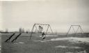
| Date: | |
|---|---|
| Description: | Recreational grounds near the beach at Terry Andrae State Park. A woman and a child are on a swing set. There are teeter totters on the left. |
If you didn't find the material you searched for, our Library Reference Staff can help.
Call our reference desk at 608-264-6535 or email us at: