 Filter: Categories of Wisconsin Historical Images
Filter: Subject of State parks and reserves
Filter: Subject of water
Filter: Subject of land
Filter: Year of 1900-1999
Filter: Categories of Wisconsin Historical Images
Filter: Subject of State parks and reserves
Filter: Subject of water
Filter: Subject of land
Filter: Year of 1900-1999
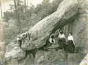
| Date: | 1905 |
|---|---|
| Description: | Six young women posed among the rocks at Devil's Lake. |
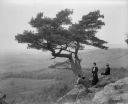
| Date: | 1902 |
|---|---|
| Description: | Two women and a man pose atop Gibraltar Rock in Richmond Memorial Park, which was dedicated by Jens Jensen and the Wisconsin Friends in 1927 in order to co... |
| Date: | 07 29 1928 |
|---|---|
| Description: | Pine Point, high above Devil's Lake. |
| Date: | 07 29 1928 |
|---|---|
| Description: | Pine Point, high above Devil's Lake. |
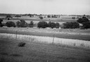
| Date: | 1945 |
|---|---|
| Description: | Field prior to the park's reconstruction, with a fence in the foreground. A river is at the bottom of the hill. |
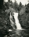
| Date: | 1935 |
|---|---|
| Description: | View from rocky shoreline towards the Brownstone Falls in Copper Falls State Park. |
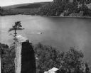
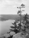
| Date: | 1948 |
|---|---|
| Description: | View from the east bluff of lake with a motorboat. A geologic pinnacle juts out from the lower left of the image. |
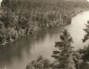
| Date: | 1940 |
|---|---|
| Description: | Elevated view of a canoe on the St. Croix River with wooded areas on both sides within the Interstate State Park. Established in 1900, Interstate Park was... |
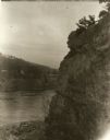
| Date: | 1929 |
|---|---|
| Description: | View of the rock formation known as the "Old Man of the Dalles" in the Interstate State Park near Saint Croix Falls, Wisconsin. The St. Croix River is in t... |
| Date: | 1963 |
|---|---|
| Description: | Elevated view of the Dalles on the Saint Croix River with boats docked and crossing. |

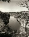
| Date: | 1945 |
|---|---|
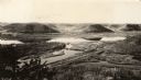
| Description: | Wyalusing State Park in the Prairie du Chein vicinity. The Wisconsin River is in the foreground and the Mississippi river can be seen below with distant bl... |
| Date: | 1950 |
|---|---|
| Description: | A view from a bluff on Tower HIll overlooking the Wisconsin River. A sign on the right reads: "Shot Shaft". |
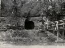
| Date: | 1950 |
|---|---|
| Description: | View across river towards the tunnel leading to the bottom of the shot tower shaft at Tower Hill State Park. There is a rustic bridge on the right leading ... |

| Date: | 1960 |
|---|---|
| Description: | View of Ennis Lake, also known as Fountain Lake, located in the John Muir Memorial Park near Montello. As a boy, John Muir lived with his family on the sho... |

| Date: | 1960 |
|---|---|
| Description: | View of Ennis Lake, also known as Fountain Lake, located in the John Muir Memorial Park near Montello. As a boy, John Muir lived with his family on the sho... |

| Date: | 1939 |
|---|---|
| Description: | A color, pictorial map. Scale: 10 miles to the inch. Shows state parks and forests, proposed state parkways, proposed state monuments and memorials, nation... |
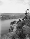
| Date: | 1930 |
|---|---|
| Description: | Elevated view of Perrot State Park (Trempealeau vicinity) looking west from Brady's Bluff toward the Mississippi River and Minnesota. Railroad tracks run a... |

| Date: | 1930 |
|---|---|
| Description: | Aerial view looking east at Mt. Trempealeau from Brady's Bluff in Perrot State Park. The Mississippi River is visible along the bluffs at upper left, and t... |

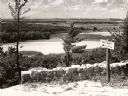
| Date: | 1954 |
|---|---|
| Description: | View looking west from Eagle Bluff toward Nicolet Bay, the Strawberry Islands, and Chambers Island. Three people are sitting on the stone wall of the overl... |
| Date: | 1960 |
|---|---|
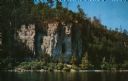
| Description: | View across water towards the 180-foot high Eagle Bluff. The bluff received its name from the eagles which formerly nested there. |
If you didn't find the material you searched for, our Library Reference Staff can help.
Call our reference desk at 608-264-6535 or email us at: