 Filter: Categories of Wisconsin Historical Images
Filter: Subject of State parks and reserves
Filter: Subject of water
Filter: Creator Name of Wisconsin. Conservation Department.
Filter: Categories of Wisconsin Historical Images
Filter: Subject of State parks and reserves
Filter: Subject of water
Filter: Creator Name of Wisconsin. Conservation Department.
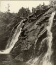
| Date: | 1935 |
|---|---|
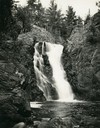
| Description: | View from rocky shoreline towards the Brownstone Falls in Copper Falls State Park. |
| Date: | 1948 |
|---|---|
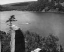
| Description: | View from the east bluff of lake with a motorboat. A geologic pinnacle juts out from the lower left of the image. |
| Date: | 1950 |
|---|---|
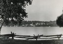
| Description: | Downtown Ephraim from Peninsula State Park, directly across the bay. |

| Date: | 1945 |
|---|---|
| Description: | Wyalusing State Park in the Prairie du Chein vicinity. The Wisconsin River is in the foreground and the Mississippi river can be seen below with distant bl... |
| Date: | 1965 |
|---|---|
| Description: | The Lake Michigan shoreline in the Kohler-Andrae State Park, named after John Michael Kohler and Terry Andrae. |
| Date: | 1965 |
|---|---|
| Description: | The sand dunes in Kohler-Andrae State Park, named after John Michael Kohler and Terry Andrae. |
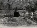
| Date: | 1950 |
|---|---|
| Description: | View across river towards the tunnel leading to the bottom of the shot tower shaft at Tower Hill State Park. There is a rustic bridge on the right leading ... |
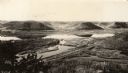
| Date: | 1930 |
|---|---|
| Description: | Elevated view of Perrot State Park (Trempealeau vicinity) looking west from Brady's Bluff toward the Mississippi River and Minnesota. Railroad tracks run a... |

| Date: | 1930 |
|---|---|
| Description: | Aerial view looking east at Mt. Trempealeau from Brady's Bluff in Perrot State Park. The Mississippi River is visible along the bluffs at upper left, and t... |
| Date: | 1938 |
|---|---|
| Description: | Little Manitou Falls on the Black River. Referred to as the "upper falls" in the park. A person is sitting on the rocks on top of the falls. This waterfall... |

| Date: | 1937 |
|---|---|
| Description: | This map shows the Wisconsin Conservation Department forest protection divisions and the locations of state forests, national forests, Indian reservations,... |

| Date: | 1937 |
|---|---|
| Description: | This Wisconsin Conservation Department map shows the locations of game refuges, fish hatcheries, canning factories, fish camps, and fish refuges in the sta... |

| Date: | 1937 |
|---|---|
| Description: | This Wisconsin Conservation Department map shows the locations of state forests, national forests, county forests, state nurseries, Indian reservations, st... |

| Date: | 05 01 1938 |
|---|---|
| Description: | This map shows the locations of Wisconsin Conservation Department forest protection districts and cooperative areas, state forests, national forests, India... |

| Date: | 1933 |
|---|---|
| Description: | This 1933 Wisconsin Conservation Dept. map shows roads, railroads, trails, lakes and streams, and the Trout Lake Game Refuge in Northern State Forest (whic... |
| Date: | |
|---|---|
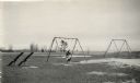
| Description: | Recreational grounds near the beach at Terry Andrae State Park. A woman and a child are on a swing set. There are teeter totters on the left. |
| Date: | |
|---|---|
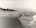
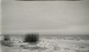
| Description: | White sand and breaking waves along the beach at Terry Andrae State Park. |
| Date: | |
|---|---|
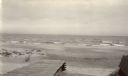
| Description: | Beach at Terry Andrae State Park. There is a wooden boardwalk in the foreground. |
| Date: | |
|---|---|
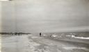
| Description: | View along shoreline showing the wide sandy swimming beach along Lake Michigan at Terry Andrae State Park. Two people are on the shoreline. |
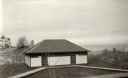
| Date: | |
|---|---|
| Description: | The bathhouse and wooden boardwalks at the swimming beach, Terry Andrae State Park. |
If you didn't find the material you searched for, our Library Reference Staff can help.
Call our reference desk at 608-264-6535 or email us at: