 Filter: Categories of Wisconsin Historical Images
Filter: Subject of State parks and reserves
Filter: Subject of trails
Filter: Categories of Wisconsin Historical Images
Filter: Subject of State parks and reserves
Filter: Subject of trails
| Date: | |
|---|---|
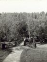
| Description: | Two people on a rustic bridge over Bad River at Copper Falls State Park. |
| Date: | |
|---|---|
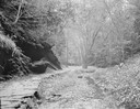
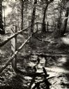
| Description: | Stone path at entrance of Cold Water Canyon. |
| Date: | 1945 |
|---|---|
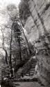
| Description: | Tower Hill State Park trail leading to the top of the shot tower shaft. |
| Date: | 1945 |
|---|---|
| Description: | Tower Hill State Park trail to the top of the shot tower shaft. |
| Date: | 1963 |
|---|---|
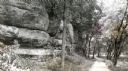
| Description: | A trail leading into Parfrey's Glen in Devil's Lake State Park. Parfrey's Glen was Wisconsin's first State Natural Area in 1952. |
| Date: | |
|---|---|
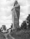
| Description: | Sculpted by Lorado Taft, and dedicated in 1911, this statue of a Native American man wrapped in a blanket stands 48 feet tall and was originally named "The... |

| Date: | |
|---|---|
| Description: | Entrance to Cold Water Canyon near Wisconsin Dells. In the foreground is a wooden walkway across the water. |

| Date: | |
|---|---|
| Description: | Photographic postcard of an old Indian trail marker, a twisted tree, as seen on top of Blue Mounds. Text below reads: "'Old Indian Trail Marker' Top of Blu... |
| Date: | 1913 |
|---|---|
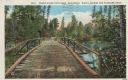
| Description: | Colorized postcard of a wooden bridge over the Brule River flowing through the forest. A person is on the far side of the bridge. Caption reads: "Brule Riv... |
| Date: | 1913 |
|---|---|
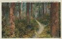
| Description: | Colorized postcard of a hiking trail winding through the forest. Some trees are showing autumn color. Caption reads: "Brule River State Park, Wisconsin. Al... |

| Date: | 1968 |
|---|---|
| Description: | The map shows fire towers, public camp grounds, roads, snow mobile & riding trails, trout lakes, foot trails, railroads, and National Forest boundaries. |

| Date: | 1994 |
|---|---|
| Description: | This brochure consists of a series of 16 maps of the Military Ridge State Park Trail and the Sugar River State Trail. In all, 62 miles of bike trails and 1... |
| Date: | 08 1976 |
|---|---|
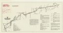
| Description: | A map that shows the trail route and detours from Rice Lake, in Barron County, through Washburn and Sawyer counties, to Park Falls, in Price County. A mile... |

| Date: | 1916 |
|---|---|
| Description: | This Wisconsin Conservation Commission map from 1916 shows Peninsula State Park in the Town of Gibraltar, Door County, Wisconsin. Depicted are open and pla... |

| Date: | 1916 |
|---|---|
| Description: | This version of a 1916 Wisconsin Conservation Commission map shows Peninsula State Park in the Town of Gibraltar, Door County, Wisconsin. Depicted are open... |

| Date: | 1920 |
|---|---|
| Description: | This map of Devil's Lake State Park in Sauk County, Wisconsin, shows the park limits, railroads, roads, creeks, trails, and points of interest in the area.... |

| Date: | 1926 |
|---|---|
| Description: | Map showing Devil's Lake State Park limits, railroads, roads, creeks, trails, and park sites. Accompanying text about the location, natural features, attra... |

| Date: | |
|---|---|
| Description: | View down trail along steep hill in the woods with birch and pine trees. A sign posted on a tree reads: "To The Cave." |

| Date: | 02 1937 |
|---|---|
| Description: | This topographical map of the forest preserve shows highways, roads, trails, telephone lines, Native American reservations, Ranger sub-stations, state nurs... |

| Date: | 1935 |
|---|---|
| Description: | This topographical map of the forest preserve shows highways, roads, trails, telephone lines, Native American reservations, Ranger sub-stations, state nurs... |
If you didn't find the material you searched for, our Library Reference Staff can help.
Call our reference desk at 608-264-6535 or email us at: