 Filter: Categories of Wisconsin Historical Images
Filter: Subject of Slavery
Filter: Subject of human settlements
Filter: Subject of social issues
Filter: Categories of Wisconsin Historical Images
Filter: Subject of Slavery
Filter: Subject of human settlements
Filter: Subject of social issues

| Date: | 1835 |
|---|---|
| Description: | Map reads: "Map of the United States of America with its Territories and Districts - Including also a part of Upper and Lower Canada and Mexico". The map i... |
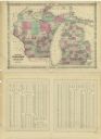
| Date: | 1864 |
|---|---|
| Description: | A map of Wisconsin and Michigan showing the counties, named towns, cities and villages, and railroads. The opposite side includes a lists counties with pop... |

| Date: | 1783 |
|---|---|
| Description: | This map is hand-colored and shows the boundaries of British, Spanish, and the newly recognized American claims, as well as the fishing rights granted to F... |
If you didn't find the material you searched for, our Library Reference Staff can help.
Call our reference desk at 608-264-6535 or email us at: