 Filter: Categories of Wisconsin Historical Images
Filter: Subject of Signs and symbols
Filter: County of Milwaukee
Filter: Type of Map or Atlas
Filter: Categories of Wisconsin Historical Images
Filter: Subject of Signs and symbols
Filter: County of Milwaukee
Filter: Type of Map or Atlas

| Date: | 1863 |
|---|---|
| Description: | Includes index to public buildings, churches, schools. Inset: Glidden & Lockwood’s addition. Gives names of some property owners. |

| Date: | 1869 |
|---|---|
| Description: | This map was engraved from original drawings and surveys taken by Louis Lipman. Includes Milwaukee street directory on the left hand side. Bottom right cor... |

| Date: | 1880 |
|---|---|
| Description: | Map created from original drawing and surveys taken by Silas Chapman. Bottom right corner features a reference key. There is a street guide on the left sid... |

| Date: | 1960 |
|---|---|
| Description: | Color coded map in pink, yellow, blue, and brown of Milwaukee County State and County trunk highways. The map includes a legend of symbols: "STEAM RAIL ROA... |

| Date: | 1938 |
|---|---|
| Description: | Color coded map in pink, yellow, blue, and brown of Milwaukee County State and County trunk highways. The map includes a legend of symbols: "STEAM RAIL ROA... |

| Date: | 1964 |
|---|---|
| Description: | This map shows various zoning sections and includes labeled streets, parks, and cemeteries. The upper left corner contains a legend of land use. |

| Date: | 1896 |
|---|---|
| Description: | This map shows streets, wards, railroads, parks, cemeteries, and Lake Michigan. Also included are explanations and an index of points of interest. |

| Date: | 1887 |
|---|---|
| Description: | This map shows sewers, manholes, streets, canals, rivers, and Lake Michigan. An explanation of sewer types is included. |

| Date: | 1936 |
|---|---|
| Description: | Color coded map in pink, yellow, blue, and brown of Milwaukee County State and County trunk highways. The map includes a legend of symbols: "STEAM RAIL ROA... |
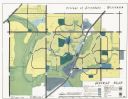
| Date: | 1962 |
|---|---|
| Description: | This map shows zoning, community facilities, roads, rivers and thoroughfares. The lower right corner includes a key titled "General Plan". |
If you didn't find the material you searched for, our Library Reference Staff can help.
Call our reference desk at 608-264-6535 or email us at: