 Filter: Categories of Wisconsin Historical Images
Filter: Subject of Shorelines
Filter: Subject of fortification
Filter: Categories of Wisconsin Historical Images
Filter: Subject of Shorelines
Filter: Subject of fortification

| Date: | 1851 |
|---|---|
| Description: | A rare photograph of U.S. Army soldiers stationed at Fort Howard rowing a boat on the Fox River. Fort Howard, built in 1816, was the first in the chain of ... |

| Date: | 1842 |
|---|---|
| Description: | This hand-colored lithograph of the second Fort Howard, with Indians canoeing on the Fox River, shows the hospital built 1834-1835 outside the stockade on ... |

| Date: | 1835 |
|---|---|
| Description: | Little Lake Butte Des Morts just north of Lake Winnebago where Governor Lewis Cass of Michigan, and Thomas McKenney, head of the Bureau of Indian Affairs (... |

| Date: | 06 24 1849 |
|---|---|
| Description: | Original wash drawing of Fort Laramie, Wyoming (actually Fort John; see note below). Sketched by Wilkins on his 151-day journey from Missouri to California... |
| Date: | 1860 |
|---|---|
| Description: | Nine men arrive at Fort William by canoe. Fort William, also called Kaministiguia, was the Hudson's Bay fur trading post. Men are standing along the opposi... |

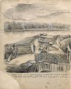
| Date: | 1831 |
|---|---|
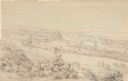
| Description: | Drawing of Fort Winnebago (near present-day Portage) that illustrated "Wau-Bun," Juliette Kinzie's memoir of her experiences on the early Wisconsin fronti... |

| Date: | 1848 |
|---|---|
| Description: | The first Fort Crawford at Prairie du Chien, with the Mississippi River in the foreground. Although dated 1830, this scene was actually painted by Henry Le... |

| Date: | 1851 |
|---|---|
| Description: | View of five soldiers rowing in a boat, beside a dock, with another soldier standing on the dock. The fort is in the background, complete with the fortifie... |

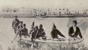
| Date: | 1851 |
|---|---|
| Description: | Several men rowing in a boat near Fort Howard that has an American Flag, barracks, and various related military buildings enclosed behind a wall. |
| Date: | |
|---|---|
| Description: | Drawing of a section of a completed part of Fort Cairo facing the confluen [sic] of the Mississippi and Ohio rivers. |

| Date: | 1814 |
|---|---|
| Description: | Fort Shelby, built by the Americans during the War of 1812. In 1814 the fort surrendered to British forces led by Captain Andrew W. Bulger who renamed it F... |

| Date: | 1840 |
|---|---|
| Description: | Fort Crawford (the second site, with buildings of 1829-?), on the east bank of the Mississippi River, about 2 miles above the mouth of the Wisconsin River. |
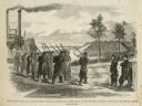
| Date: | 02 28 1863 |
|---|---|
| Description: | The First Regiment of the Louisiana Native Guards disembarking at Fort Macomb, Louisiana. The fort is adjacent to the Venetian Isles community, now legally... |
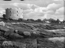
| Date: | |
|---|---|
| Description: | View from rocky shore toward the stone tower at Fort William Henry. Four automobiles are parked in front of the tower, with houses and other buildings in t... |

| Date: | |
|---|---|
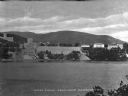
| Description: | Elevated view of Fort Seward from Mount Rippinsky, showing Pyramid Harbor and Davidson Glacier in distance. Caption reads: "Haines and Fort Wm. H. Seward f... |
| Date: | |
|---|---|
| Description: | A view of West Point from Garrison, New York, across the river. The military academy was designed in l778, and was built on the bank of the Hudson River. C... |

| Date: | |
|---|---|
| Description: | Preliminary sketch for "Fort Pillow upon the Eve of the Evacuation by the Rebels". |

| Date: | 1866 |
|---|---|
| Description: | Exterior of Fort Sumter. A cannon has fallen on the steep shoreline and waves are hitting the rocks. Plate 58 |

| Date: | 1865 |
|---|---|
| Description: | Exterior of Fort Sumpter [sic]. There are several men and a boat on the shoreline in the foreground. Plate 56 |
| Date: | 1852 |
|---|---|
| Description: | Landscape view of Fort Snelling, Minnesota Territory from a nearby hill showing the Fort, the Mississippi river, the countryside, farm buildings and tipis.... |
If you didn't find the material you searched for, our Library Reference Staff can help.
Call our reference desk at 608-264-6535 or email us at: