 Filter: Categories of Wisconsin Historical Images
Filter: Subject of Shorelines
Filter: Subject of exploration
Filter: Categories of Wisconsin Historical Images
Filter: Subject of Shorelines
Filter: Subject of exploration
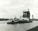
| Date: | 1967 |
|---|---|
| Description: | NASA towboat, the "Clermont", pulling a liquid oxygen tank in the canal system of the Mississippi Test Support Department. Original caption reads (in part)... |

| Date: | 1786 |
|---|---|
| Description: | One half of a four sheet nautical chart, showing the coastlines of the north-west hemisphere. The interior lands are left bare, even of basic features such... |

| Date: | 1788 |
|---|---|
| Description: | This map shows the north western coast of North America, including the southern coast of what will be Alaska and parts of the Aleutian Islands. It includes... |

| Date: | 1759 |
|---|---|
| Description: | Map of north eastern Canada and parts of New England, showing settlements, cities, portages, Native American land, mountains, lakes, and rivers. The unusua... |
If you didn't find the material you searched for, our Library Reference Staff can help.
Call our reference desk at 608-264-6535 or email us at: