 Filter: Categories of Wisconsin Historical Images
Filter: Subject of Shorelines
Filter: Subject of aids to navigation
Filter: Categories of Wisconsin Historical Images
Filter: Subject of Shorelines
Filter: Subject of aids to navigation

| Date: | 07 22 1949 |
|---|---|
| Description: | Tenney Park breakwater and Lake Mendota. The city of Madison was able to resume construction at no cost. The construction company tearing up East Washingto... |

| Date: | 1890 |
|---|---|
| Description: | View from the shore of Kenosha's North Pier and lighthouse. Waves are breaking on the shore of Lake Michigan. |
| Date: | 1910 |
|---|---|
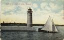
| Description: | Hand-colored postcard view of a pier and lighthouse at the entrance to Milwaukee's harbor. Two people sail in a small boat to the right of the lighthouse, ... |

| Date: | |
|---|---|
| Description: | Postcard view along icy shoreline of the pier and lighthouse on Lake Michigan at Port Washington in winter. |

| Date: | |
|---|---|
| Description: | Winter view of the lighthouse at Port Washington from the icy shore of Lake Michigan. Two people can be seen standing on a pier in the distance. |

| Date: | 1910 |
|---|---|
| Description: | Postcard view of three men on an elevated walk on an icy pier near the shoreline. A women and young boy stand on the pier below the walk. There is a lighth... |

| Date: | 1909 |
|---|---|
| Description: | This 1909 chart of the Apostle Islands, Chequamegon Bay, and the Lake Superior shoreline shows relief by contours and spot heights and depths by contours, ... |

| Date: | 1786 |
|---|---|
| Description: | One half of a four sheet nautical chart, showing the coastlines of the north-west hemisphere. The interior lands are left bare, even of basic features such... |

| Date: | 1776 |
|---|---|
| Description: | Map of the Delaware Bay, River, their shoreline, made to aid ships in navigating to Philadelphia. It is oriented with north to the right and shows inlets, ... |
If you didn't find the material you searched for, our Library Reference Staff can help.
Call our reference desk at 608-264-6535 or email us at: