 Filter: Categories of Wisconsin Historical Images
Filter: Subject of Ships
Filter: Subject of water
Filter: Categories of Wisconsin Historical Images
Filter: Subject of Ships
Filter: Subject of water

| Date: | 1867 |
|---|---|
| Description: | Bird's-eye map of Green Bay and Fort Howard, Brown Co., depicts street names and street layouts, houses, trees, and the East River. A reference key at the ... |

| Date: | 1867 |
|---|---|
| Description: | Bird's-eye map of La Crosse with nine insets of residences, schools, and the Court House and Jail. |

| Date: | 1873 |
|---|---|
| Description: | Bird's-eye map of La Crosse from the Mississippi River. |
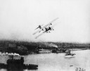
| Date: | 11 1912 |
|---|---|
| Description: | Jesse Brabazon, pioneer aviator from Delavan, flying over the Mississippi River in a Wright Model B airplane. "It was quite a sight to fly over the Mississ... |
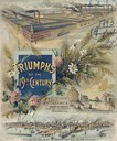
| Date: | 1893 |
|---|---|
| Description: | Cover of an advertising catalog for William Deering & Company featuring chromolithograph illustrations of the Deering factory, the grain center of the worl... |

| Date: | 1886 |
|---|---|
| Description: | Cover of an advertising brochure for the Milwaukee Harvester Company featuring a color chromolithograph illustration of a farmer in a field operating a hor... |

| Date: | 1893 |
|---|---|
| Description: | Front and back covers of an advertising brochure for the New Empire line of mowers, reapers and grain binders manufactured by J.F. Seiberling & Company. Th... |

| Date: | 1898 |
|---|---|
| Description: | Bird's-eye map of Milwaukee with prominent streets and buildings identified. Taken from City Hall Tower. |

| Date: | 1885 |
|---|---|
| Description: | Bird's-eye view of Sheboygan, with inset of J.J. Volrath Manufacturing Company. |
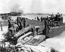
| Date: | 1944 |
|---|---|
| Description: | U.S. Marines using an International TD-9 diesel TracTracTor (crawler tractor) with a Bucyrus Erie shovel on an LCM (Landing Craft, Materiel) at Roi during ... |

| Date: | 1882 |
|---|---|
| Description: | Bird's-eye map of Lake Geneva, looking southwest, with insets of points of interest. |

| Date: | 1872 |
|---|---|
| Description: | Bird's-eye map of Milwaukee on Lake Michigan. |

| Date: | 1870 |
|---|---|
| Description: | Sauk City is the oldest incorporated village in Wisconsin (incorporated in 1854) and also has the oldest organized volunteer fire department in the state, ... |

| Date: | 1883 |
|---|---|
| Description: | Bird's-eye map of Superior, county seat of Douglas County, on the shores of Lake Superior, with insets of points of interest. |

| Date: | 1913 |
|---|---|
| Description: | Bird's-eye map of Superior. "The New Steel Center." |

| Date: | 1915 |
|---|---|
| Description: | Bird's-eye view of Superior, Wisconsin, and Duluth, Minnesota on opposite shore of Lake Superior. |

| Date: | 1886 |
|---|---|
| Description: | Bird's-eye map of Washburn on Lake Superior. There is an inset of Washburn, Chequamagon and the Apostle Islands. |

| Date: | 1880 |
|---|---|
| Description: | Bird's-eye map of Waukesha, county seat of Waukesha County. |

| Date: | 1874 |
|---|---|
| Description: | Bird's-eye map of Chippewa Falls. |
If you didn't find the material you searched for, our Library Reference Staff can help.
Call our reference desk at 608-264-6535 or email us at:
