 Filter: Categories of Wisconsin Historical Images
Filter: Subject of Ships
Filter: Subject of jewelry
Filter: Categories of Wisconsin Historical Images
Filter: Subject of Ships
Filter: Subject of jewelry

| Date: | 07 1959 |
|---|---|
| Description: | Dickey Chapelle, photographer, on the same Milwaukee beach where she learned to swim as a young girl. She was covering "Operation Inland Seas" celebrating ... |
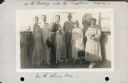
| Date: | 10 31 1930 |
|---|---|
| Description: | Alma Seipp Hay, second from right, and her husband, William Sherman Hay, third from left, join Commander C.W. Berndtson and other passengers on the bridge... |

| Date: | 1684 |
|---|---|
| Description: | Map of North America showing some colonies, cities, rivers, lakes, and Native American land. Ship routes spread across both oceans, including one decorated... |

| Date: | 1770 |
|---|---|
| Description: | Map of North America from the Great Lakes to the northern portion of South America. It shows cities, Native American land, mountains, swamps, lakes, rivers... |
If you didn't find the material you searched for, our Library Reference Staff can help.
Call our reference desk at 608-264-6535 or email us at: