 Filter: Categories of Wisconsin Historical Images
Filter: Subject of Ships
Filter: Subject of canoes and canoeing
Filter: Categories of Wisconsin Historical Images
Filter: Subject of Ships
Filter: Subject of canoes and canoeing

| Date: | 1873 |
|---|---|
| Description: | Bird's-eye map of La Crosse from the Mississippi River. |
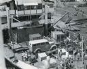
| Date: | 1938 |
|---|---|
| Description: | Elevated view of men unloading trucks and equipment from a ship shortly after arrival in the African Congo. The equipment was used by Commander Atillio Gat... |
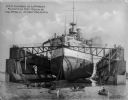
| Date: | 1901 |
|---|---|
| Description: | The USS Illinois in the largest floating dry dock in the world at the time, surrounded by rowboats in the foreground. The battleship was built at Ne... |

| Date: | 1783 |
|---|---|
| Description: | This map is hand-colored and shows the boundaries of British, Spanish, and the newly recognized American claims, as well as the fishing rights granted to F... |

| Date: | 1718 |
|---|---|
| Description: | Map of the Southern portion of North America from New Mexico to Florida and south from Lake Erie. It shows borders, cities, settlements, Native American la... |
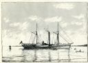
| Date: | 1895 |
|---|---|
| Description: | Drawing of the Great Lakes steamer Walk-in-the-Water. |
If you didn't find the material you searched for, our Library Reference Staff can help.
Call our reference desk at 608-264-6535 or email us at: