 Filter: Categories of Wisconsin Historical Images
Filter: Subject of Ships
Filter: Subject of bridges
Filter: Categories of Wisconsin Historical Images
Filter: Subject of Ships
Filter: Subject of bridges

| Date: | 1881 |
|---|---|
| Description: | Bird's-eye map of Marinette, with insets. |

| Date: | 1855 |
|---|---|
| Description: | Quarter plate daguerreotype of the Oshkosh harbor, showing the bridge over the Fox River and several moored sailing vessels. |

| Date: | 1856 |
|---|---|
| Description: | View looking west from Lake Michigan with several steam ships and sailing vessels in harbor. There is a lighthouse to left of center, along shoreline. |
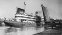
| Date: | 08 30 1906 |
|---|---|
| Description: | A screw passenger excursion vessel or whaleback, the Christopher Columbus, passing through the Broadway Bridge. |
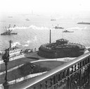
| Date: | 1900 |
|---|---|
| Description: | Elevated view, probably early 20th century New York Harbor. |
| Date: | |
|---|---|
| Description: | Elevated view of Milwaukee River from Walker's Point Bridge. |
| Date: | |
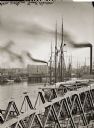
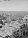
|---|---|
| Description: | Milwaukee, south from Mitchell Block. View shows rooftops and building fronts. Ships and bridge are in the background on the right. |
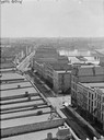
| Date: | |
|---|---|
| Description: | Milwaukee, northwest from Mitchell block. Elevated view of rooftops and buildings with River in background. |

| Date: | 1867 |
|---|---|
| Description: | Birds-eye drawing of Appleton, Outagamie Co., depicting street names and street layout, houses, the Fox River, the court house, jail, school houses, Lawren... |

| Date: | 1867 |
|---|---|
| Description: | Bird's-eye map of Green Bay and Fort Howard, Brown Co., depicts street names and street layouts, houses, trees, and the East River. A reference key at the ... |

| Date: | 1867 |
|---|---|
| Description: | Bird's-eye map of La Crosse with nine insets of residences, schools, and the Court House and Jail. |

| Date: | 1873 |
|---|---|
| Description: | Bird's-eye map of La Crosse from the Mississippi River. |

| Date: | 1882 |
|---|---|
| Description: | Bird's-eye views of various sections of Milwaukee. |

| Date: | 1885 |
|---|---|
| Description: | Bird's-eye view of Sheboygan, with inset of J.J. Volrath Manufacturing Company. |

| Date: | 1872 |
|---|---|
| Description: | Bird's-eye map of Milwaukee on Lake Michigan. |

| Date: | 1870 |
|---|---|
| Description: | Sauk City is the oldest incorporated village in Wisconsin (incorporated in 1854) and also has the oldest organized volunteer fire department in the state, ... |

| Date: | 1915 |
|---|---|
| Description: | Bird's-eye view of Superior, Wisconsin, and Duluth, Minnesota on opposite shore of Lake Superior. |

| Date: | 1874 |
|---|---|
| Description: | Bird's-eye map of Chippewa Falls. |
If you didn't find the material you searched for, our Library Reference Staff can help.
Call our reference desk at 608-264-6535 or email us at:

